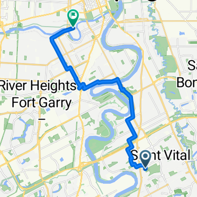
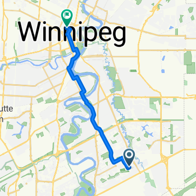
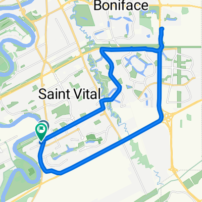
Assiniboine Park - Winnipeg, MB
- 13.9 km
- 13 m
- 14 m
- Winnipeg, Manitoba, Canada
A cycling route starting in Winnipeg, Manitoba, Canada.
Overview
created this 4 years ago
Route quality
Quiet road
7.7 km
(50 %)
Cycleway
4.6 km
(30 %)
Paved
11.6 km
(75 %)
Unpaved
1.5 km
(10 %)
Asphalt
8 km
(52 %)
Concrete
3.1 km
(20 %)
Route highlights
Note the route heads down the back lane at this point and not as indicated

Making a slight detour trough the back lane allows you to see some of the incredible Kal Barteski’s Back Alley Arctic art on garages and fences. https://bit.ly/2ZIJxIZ
Wolseley is currently one of the City of Winnipeg's "Enhanced Cycling Routes" where motor vehicle travel is limited to 1 block. This is schedule to end in early November and we need Winnipeggers to lobby for how this can either be extended or enhanced year round.
There are 2 possible routes through Omands Park. The one indicated takes the rider north along Raglan, through the church parking lot, west on the sidewalk and then back long the trails on the west side of the park. The alternative is a somewhat steep incline with a couple of shark turns to a bridge across Omand's Creek and then a longer climb back up to the trail leading west. This bridge is frequently flooded in spring forcing riders and other users to take the longer route north to Portage. A new bridge has been proposed in the past and we need to continue to push for an improved crossing on this important commuter route. Note that the signage indicating the bike route send cyclists down the slope and over the bridge.

This sidewalk while used by bike regularly is not a shared use path and thus in essence, illegal.
This area used to be trees and low brush that provided a buffer between the rial line and the park but Manitoba Hydro cut it all down much to the chagrin of park users.
Connection point to the Empress multi-use path going north to St. Matthews.

Note: Bike Route signage heading west sends bikes north to Portage.

This section between the junction of Wolseley W and parking lot for Kiltarton Towers is in very poor condition and needs to be repaired/reconstructed or an alternative provided.

Blind corner around the Herzing College building.
No left turn heading west here except for cyclists.

Entrance to the path leading west through Jae Eadie Park appears to be a driveway and is not signed as a bike route.
Entrance to Jae Eadie Park not signed as a bike route.
Assiniboine Avenue from Parkside to Ferry is a one of the City of Winnipeg's "Enhanced Cycling Routes" where motor vehicle travel is limited to 1 block. In this case it is not 7 days a week but restricted to weekends and holidays. While this should be full time it is schedule to end in early November and we need Winnipeggers to lobby for how this can either be extended or enhanced year round.
Bourkevale Community Centre has created the "Bourkvale 30" campaign to try and reduce the area’s speed limit to 30 km/hr and create a safer and more active neighbourhood. They have support from their city councillor Scott Gillingham and hoe to be part of potential future pilot projects. More info at https://bit.ly/3l4vOoo
Bike route cuts through parking lot for Bourkvale Community Center to the multi-use path through Bourkvale Park.

Riders not wanting to ride the entire 14 km route can use the round about to return back east through Bourkvale Park.

Entrance into heading west into Bruce Park.
The route through Bruce Park includes a steep decline heading west with 2 tight corners. Can be difficult for cargo bikes, trailers or trail-a-bikes. Alternative option is north on Douglas Park Road to Portage, west on the sidewalk along Portage and south on Albany to connect with Deer Lodge Place.
Steep decline/incline with tight corners can be difficult cargo bikes, trailers or trail-a-bikes.

Narrow bridge crossing.
The route through Bruce Park includes a steep incline, narrow bridge and 2 tight corners. Can be difficult for cargo bikes, trailers or trail-a-bikes. Alternative option is north on Albany to Portage, east on the sidewalk along Portage and south on Douglas Park Road to the entrance to Bourkvale Park.
Entrance/exit to Assiniboine Park.

Entrance to bridge cyclists are to dismount. When the bridge is busy it is best to just walk however at other times it is advisable to ride a pedestrian speed.
Entrance to bridge cyclists are to dismount. When the bridge is busy it is best to just walk however at other times it is advisable to ride at pedestrian speed.
Multi-use path in some areas it is rough and can be quite busy so bike need to yield to people walking.
Option to cross Assinboine Park Drive and use the multi-use path.

Want to ride some newly developed single track for a bit of fun. Here is your opportunity. Jump off the multi-use path and take the trail heading west. There is also a bike park for kids to try out their skills.
Ride the single track.

Want to ride some newly developed single track for a bit of fun. Here is your opportunity. Jump off the multi-use path and take the trail heading east.
Continue on the multi-use path or jump onto Wellington Crescent. Wellington Crescent is currently one of the City of Winnipeg's "Enhanced Cycling Routes" where motor vehicle travel is limited to 1 block. This is schedule to end in early November and we need Winnipeggers to lobby for how this can either be extended or enhanced year round.
Wellington is currently one of the City of Winnipeg's "Enhanced Cycling Routes" where motor vehicle travel is limited to 1 block. This is schedule to end in early November and we need Winnipeggers to lobby for how this can either be extended or enhanced year round.
Steep decline/incline
This pedestrian bridge adjacent to the rail bridge is very narrow. Bike riders are expected to dismount and ride however walking adjacent to your bike further reduces clearance between individuals crossing in opposite directions.
Note: Many people on bikes will cut across Wellington at this point to use the sidewalk over the bridge on the east side. While a safe option as long as you are careful crossing traffic on Wellington, riding on the sidewalk is still illegal.

The intersection of Wellington and Academy heading east can be difficult for those riders turning left to head over the Maryland Bridge and onto Sherbrook. People on bike should take their position in the turning lane and make the turn when safe to do so. The alternative is to use a pedestrian turn, dismount and walk across Academy at the light, wait and then again walk across Wellington heading east before remounting and riding across the bridge. Note: There is no bike lane on the bridge. only a shy lane and cyclists should maintain a 1 meter distance from the concrete barrier.
The shy lane across the bridge does not represent a bike lane and cyclists should maintain a 1 meter distance from the concrete barrier which in most cases will be close to the solid white line that delineates that shy lane.
Once across the bridge you will enter a painted bike lane on Sherbrook.

Watch carefully for right turning motor vehicles onto Wolseley.
Painted bike lane transitions to a parking protected bike lane where parked cars are now on the left side of the bike lane.

Protected bike lane along Westminister heading east.

In order to head north on Young Street to Broadway Neighbourhood Centre bike need to leave the protected bike lane at the stop sign and join car traffic turning to head north. If you continue in the protected bike lane there is no option to continue onto Young and you need to follow the protected bike lane east to Spence and then turnaround and head back to Young Street.

At this intersection heading west cyclists have to transition from the bi-directional bike lane to the single bike lane on the north side of Westminister heading west. Their are stop signs for all cars entering/turning at the intersection however you need to be careful when making the transition to the bike lane heading west.

The protected bike lane does not allow access to young street. At this point the option is to carry on east to Spence and use the road to return to young street.
Continue with Bikemap
You would like to ride Wolseley ride or customize it for your own trip? Here is what you can do with this Bikemap route:
Free trial for 3 days, or one-time payment. More about Bikemap Premium.
Discover more Premium features.
Get Bikemap PremiumFrom our community
Open it in the app