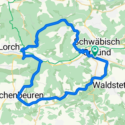
Hohenstaufenrunde
A cycling route starting in Schwäbisch Gmünd, Baden-Württemberg, Germany.
Overview
About this route
Tagestour mit Susanne und Manfred, Stauffenburgen
- -:--
- Duration
- 28.7 km
- Distance
- 605 m
- Ascent
- 605 m
- Descent
- ---
- Avg. speed
- ---
- Avg. speed
Continue with Bikemap
Use, edit, or download this cycling route
You would like to ride Hohenstaufenrunde or customize it for your own trip? Here is what you can do with this Bikemap route:
Free features
- Save this route as favorite or in collections
- Copy & plan your own version of this route
- Sync your route with Garmin or Wahoo
Premium features
Free trial for 3 days, or one-time payment. More about Bikemap Premium.
- Navigate this route on iOS & Android
- Export a GPX / KML file of this route
- Create your custom printout (try it for free)
- Download this route for offline navigation
Discover more Premium features.
Get Bikemap PremiumFrom our community
Other popular routes starting in Schwäbisch Gmünd
- Abendliche Zeitfahrtrainingsrunde
- Distance
- 27 km
- Ascent
- 282 m
- Descent
- 282 m
- Location
- Schwäbisch Gmünd, Baden-Württemberg, Germany
- Ulm,Arneg
- Distance
- 59.7 km
- Ascent
- 731 m
- Descent
- 572 m
- Location
- Schwäbisch Gmünd, Baden-Württemberg, Germany
- Kurze Fürtlespass Runde
- Distance
- 34.6 km
- Ascent
- 485 m
- Descent
- 485 m
- Location
- Schwäbisch Gmünd, Baden-Württemberg, Germany
- Johannisplatz 10, Schwäbisch Gmünd nach Johannisplatz 10, Schwäbisch Gmünd
- Distance
- 55.7 km
- Ascent
- 614 m
- Descent
- 615 m
- Location
- Schwäbisch Gmünd, Baden-Württemberg, Germany
- Kurze Feierabendrunde
- Distance
- 23.3 km
- Ascent
- 338 m
- Descent
- 351 m
- Location
- Schwäbisch Gmünd, Baden-Württemberg, Germany
- alb rauf und runter
- Distance
- 98.6 km
- Ascent
- 1,359 m
- Descent
- 1,361 m
- Location
- Schwäbisch Gmünd, Baden-Württemberg, Germany
- lazy Sunday alternoon
- Distance
- 23.3 km
- Ascent
- 251 m
- Descent
- 257 m
- Location
- Schwäbisch Gmünd, Baden-Württemberg, Germany
- Hohenstaufenrunde
- Distance
- 28.7 km
- Ascent
- 605 m
- Descent
- 605 m
- Location
- Schwäbisch Gmünd, Baden-Württemberg, Germany
Open it in the app