
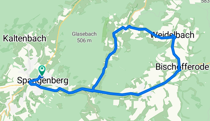
"Über die Weidelbacher-Höhe" (Geg. Uhrz.) CLONED FROM ROUTE 977521
A cycling route starting in Spangenberg, Hesse, Germany.
Overview
About this route
Route without major 'topographical obstacles'. Little vehicle traffic. Almost entirely good asphalt, only a bit bumpy just behind Weidelbach and in the area of Vockerode-Dinkelberg.
- -:--
- Duration
- 20.1 km
- Distance
- 201 m
- Ascent
- 200 m
- Descent
- ---
- Avg. speed
- ---
- Max. altitude
Continue with Bikemap
Use, edit, or download this cycling route
You would like to ride "Über die Weidelbacher-Höhe" (Geg. Uhrz.) CLONED FROM ROUTE 977521 or customize it for your own trip? Here is what you can do with this Bikemap route:
Free features
- Save this route as favorite or in collections
- Copy & plan your own version of this route
- Sync your route with Garmin or Wahoo
Premium features
Free trial for 3 days, or one-time payment. More about Bikemap Premium.
- Navigate this route on iOS & Android
- Export a GPX / KML file of this route
- Create your custom printout (try it for free)
- Download this route for offline navigation
Discover more Premium features.
Get Bikemap PremiumFrom our community
Other popular routes starting in Spangenberg
 Spangenberg - Dörnbach - Schmachtenhagen - Mörshausen
- Distance
- 13 km
- Ascent
- 247 m
- Descent
- 247 m
- Location
- Spangenberg, Hesse, Germany
 "Col de la Wickersrode" (Geg.Uhrz.)
- Distance
- 21.6 km
- Ascent
- 298 m
- Descent
- 298 m
- Location
- Spangenberg, Hesse, Germany
 Spangenberg - Altmorschen
- Distance
- 22.1 km
- Ascent
- 544 m
- Descent
- 541 m
- Location
- Spangenberg, Hesse, Germany
 Mörshasuen nach Bad Langensalza
- Distance
- 110.4 km
- Ascent
- 691 m
- Descent
- 691 m
- Location
- Spangenberg, Hesse, Germany
 Hauptstraße 5, Spangenberg nach Am Sande 9, Witzenhausen
- Distance
- 38.6 km
- Ascent
- 325 m
- Descent
- 397 m
- Location
- Spangenberg, Hesse, Germany
 Schmachtenhagen - Adelshausen - Spangenberg
- Distance
- 14.4 km
- Ascent
- 217 m
- Descent
- 323 m
- Location
- Spangenberg, Hesse, Germany
 Bischofferode-Pfiefe-Rundtour
- Distance
- 25.1 km
- Ascent
- 582 m
- Descent
- 596 m
- Location
- Spangenberg, Hesse, Germany
 "Über die Weidelbacher-Höhe" (Geg. Uhrz.) CLONED FROM ROUTE 977521
- Distance
- 20.1 km
- Ascent
- 201 m
- Descent
- 200 m
- Location
- Spangenberg, Hesse, Germany
Open it in the app