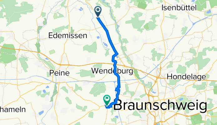
B214, Edemissen nach Meisenweg 14, Vechelde
A cycling route starting in Hillerse, Lower Saxony, Germany.
Overview
About this route
- 58 min
- Duration
- 22.2 km
- Distance
- 39 m
- Ascent
- 20 m
- Descent
- 23 km/h
- Avg. speed
- ---
- Max. altitude
Route quality
Waytypes & surfaces along the route
Waytypes
Cycleway
7.5 km
(34 %)
Path
7.3 km
(33 %)
Surfaces
Paved
20.4 km
(92 %)
Asphalt
19.9 km
(90 %)
Concrete
0.4 km
(2 %)
Undefined
1.8 km
(8 %)
Continue with Bikemap
Use, edit, or download this cycling route
You would like to ride B214, Edemissen nach Meisenweg 14, Vechelde or customize it for your own trip? Here is what you can do with this Bikemap route:
Free features
- Save this route as favorite or in collections
- Copy & plan your own version of this route
- Sync your route with Garmin or Wahoo
Premium features
Free trial for 3 days, or one-time payment. More about Bikemap Premium.
- Navigate this route on iOS & Android
- Export a GPX / KML file of this route
- Create your custom printout (try it for free)
- Download this route for offline navigation
Discover more Premium features.
Get Bikemap PremiumFrom our community
Other popular routes starting in Hillerse
- Joe Hillerse
- Distance
- 23.1 km
- Ascent
- 10 m
- Descent
- 0 m
- Location
- Hillerse, Lower Saxony, Germany
- Hil - GF - HIL
- Distance
- 36.4 km
- Ascent
- 71 m
- Descent
- 66 m
- Location
- Hillerse, Lower Saxony, Germany
- B214, Edemissen nach Meisenweg 14, Vechelde
- Distance
- 22.2 km
- Ascent
- 39 m
- Descent
- 20 m
- Location
- Hillerse, Lower Saxony, Germany
- Hillerse - Elze - Süd 87km
- Distance
- 87.2 km
- Ascent
- 212 m
- Descent
- 200 m
- Location
- Hillerse, Lower Saxony, Germany
- Offroad entlang der Oker
- Distance
- 30.6 km
- Ascent
- 72 m
- Descent
- 69 m
- Location
- Hillerse, Lower Saxony, Germany
- volkse
- Distance
- 22.3 km
- Ascent
- 26 m
- Descent
- 12 m
- Location
- Hillerse, Lower Saxony, Germany
- Hillerse zurück zum Tankumsee
- Distance
- 18.2 km
- Ascent
- 54 m
- Descent
- 62 m
- Location
- Hillerse, Lower Saxony, Germany
- HIL-WOB
- Distance
- 39.4 km
- Ascent
- 117 m
- Descent
- 118 m
- Location
- Hillerse, Lower Saxony, Germany
Open it in the app