

Overview
About this route
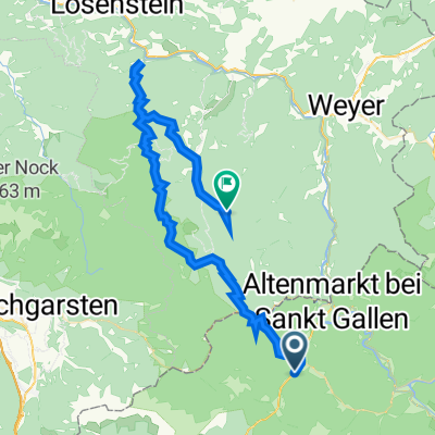
- Etappe Ennsradweg über Mooshöhe nach Losenstein
- -:--
- Duration
- 47.5 km
- Distance
- 546 m
- Ascent
- 701 m
- Descent
- ---
- Avg. speed
- 857 m
- Max. altitude

Part of
Ennsradweg 2009
5 stages
Route quality
Waytypes & surfaces along the route
Waytypes
Track
16.6 km
(35 %)
Quiet road
9.5 km
(20 %)
Surfaces
Paved
17.1 km
(36 %)
Unpaved
17.6 km
(37 %)
Gravel
16.6 km
(35 %)
Asphalt
16.2 km
(34 %)
Route highlights
Points of interest along the route
Point of interest after 16.6 km
Jausenstation Mooshöhe im Reichraminger Hintergebirge
Point of interest after 47.5 km
Gasthof Blasl Losenstein
Continue with Bikemap
Use, edit, or download this cycling route
You would like to ride St. Gallen - Losenstein or customize it for your own trip? Here is what you can do with this Bikemap route:
Free features
- Save this route as favorite or in collections
- Copy & plan your own version of this route
- Sync your route with Garmin or Wahoo
Premium features
Free trial for 3 days, or one-time payment. More about Bikemap Premium.
- Navigate this route on iOS & Android
- Export a GPX / KML file of this route
- Create your custom printout (try it for free)
- Download this route for offline navigation
Discover more Premium features.
Get Bikemap PremiumFrom our community
Other popular routes starting in Sankt Gallen
 Bodenweg 39, St. Gallen nach Lumpelgraben, Großraming
- Distance
- 57.8 km
- Ascent
- 1,684 m
- Descent
- 1,451 m
- Location
- Sankt Gallen, Styria, Austria
 Ennská stezka 🇦🇹 2021 - Den 5. - Sankt Gallen - Steyr
- Distance
- 73.5 km
- Ascent
- 4,890 m
- Descent
- 5,107 m
- Location
- Sankt Gallen, Styria, Austria
 2024_08_30_St.Gallen-Molln
- Distance
- 52.4 km
- Ascent
- 2,814 m
- Descent
- 2,859 m
- Location
- Sankt Gallen, Styria, Austria
 Kolem národního parku
- Distance
- 56.5 km
- Ascent
- 1,460 m
- Descent
- 1,400 m
- Location
- Sankt Gallen, Styria, Austria
 St. Gallen - Losenstein
- Distance
- 47.5 km
- Ascent
- 546 m
- Descent
- 701 m
- Location
- Sankt Gallen, Styria, Austria
 B117 36, Sankt Gallen nach Am Ortsplatz 1, Reichraming
- Distance
- 38.1 km
- Ascent
- 918 m
- Descent
- 1,076 m
- Location
- Sankt Gallen, Styria, Austria
 Buchsteinrunde Ennstal
- Distance
- 122.8 km
- Ascent
- 2,622 m
- Descent
- 2,625 m
- Location
- Sankt Gallen, Styria, Austria
 Sankt Gallen - Großraming - Brunnbach - Reichraming
- Distance
- 56.5 km
- Ascent
- 557 m
- Descent
- 710 m
- Location
- Sankt Gallen, Styria, Austria
Open it in the app