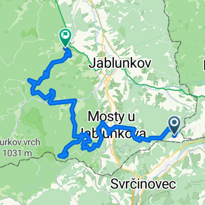
Nad údolím Lomné
A cycling route starting in Mosty u Jablunkova, Moravskoslezský kraj, Czechia.
Overview
About this route
The MTB route 'Nad údolím Lomné' mostly utilizes classic forest trails with varying degrees of maintenance. Its starting point is in Dolní Lomná (e.g., at the parking lot near the Mánes restaurant). Except for two climbs at the beginning and around the middle in the upper part of Horní Lomná, there are no long climbs, although the total elevation gain over the entire route exceeds 1000 m.
- -:--
- Duration
- 37.9 km
- Distance
- 959 m
- Ascent
- 961 m
- Descent
- ---
- Avg. speed
- ---
- Max. altitude
Continue with Bikemap
Use, edit, or download this cycling route
You would like to ride Nad údolím Lomné or customize it for your own trip? Here is what you can do with this Bikemap route:
Free features
- Save this route as favorite or in collections
- Copy & plan your own version of this route
- Sync your route with Garmin or Wahoo
Premium features
Free trial for 3 days, or one-time payment. More about Bikemap Premium.
- Navigate this route on iOS & Android
- Export a GPX / KML file of this route
- Create your custom printout (try it for free)
- Download this route for offline navigation
Discover more Premium features.
Get Bikemap PremiumFrom our community
Other popular routes starting in Mosty u Jablunkova
- Velky Javornik
- Distance
- 149.1 km
- Ascent
- 4,650 m
- Descent
- 4,626 m
- Location
- Mosty u Jablunkova, Moravskoslezský kraj, Czechia
- Slavíč - Javorový
- Distance
- 10.6 km
- Ascent
- 286 m
- Descent
- 261 m
- Location
- Mosty u Jablunkova, Moravskoslezský kraj, Czechia
- Polanka - Sance - Cadca - Zwardon - Hrcava - Polanka
- Distance
- 78.2 km
- Ascent
- 998 m
- Descent
- 998 m
- Location
- Mosty u Jablunkova, Moravskoslezský kraj, Czechia
- 00 den Mosty u Jablunkova - nejvýchodnější bod ČR
- Distance
- 28.6 km
- Ascent
- 615 m
- Descent
- 629 m
- Location
- Mosty u Jablunkova, Moravskoslezský kraj, Czechia
- Podjazd na Szańce z Mostów u J.
- Distance
- 5.7 km
- Ascent
- 170 m
- Descent
- 18 m
- Location
- Mosty u Jablunkova, Moravskoslezský kraj, Czechia
- Objezd ČR II.
- Distance
- 336.4 km
- Ascent
- 1,382 m
- Descent
- 1,578 m
- Location
- Mosty u Jablunkova, Moravskoslezský kraj, Czechia
- Z Doubravy na Slavíč
- Distance
- 10.1 km
- Ascent
- 608 m
- Descent
- 608 m
- Location
- Mosty u Jablunkova, Moravskoslezský kraj, Czechia
- Medvedia skala, Velký a Malý Polom, Bílý Kříž, Veterný mlyn Korňa
- Distance
- 40.3 km
- Ascent
- 982 m
- Descent
- 943 m
- Location
- Mosty u Jablunkova, Moravskoslezský kraj, Czechia
Open it in the app