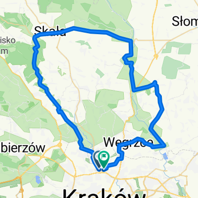
Myślenice Chełm
A cycling route starting in Zielonki, Lesser Poland Voivodeship, Poland.
Overview
About this route
- -:--
- Duration
- 90.6 km
- Distance
- 948 m
- Ascent
- 959 m
- Descent
- ---
- Avg. speed
- ---
- Max. altitude
Route quality
Waytypes & surfaces along the route
Waytypes
Quiet road
40.2 km
(44 %)
Road
27.8 km
(31 %)
Surfaces
Paved
55.5 km
(61 %)
Unpaved
0.2 km
(<1 %)
Asphalt
46.5 km
(51 %)
Paving stones
6.4 km
(7 %)
Continue with Bikemap
Use, edit, or download this cycling route
You would like to ride Myślenice Chełm or customize it for your own trip? Here is what you can do with this Bikemap route:
Free features
- Save this route as favorite or in collections
- Copy & plan your own version of this route
- Split it into stages to create a multi-day tour
- Sync your route with Garmin or Wahoo
Premium features
Free trial for 3 days, or one-time payment. More about Bikemap Premium.
- Navigate this route on iOS & Android
- Export a GPX / KML file of this route
- Create your custom printout (try it for free)
- Download this route for offline navigation
Discover more Premium features.
Get Bikemap PremiumFrom our community
Other popular routes starting in Zielonki
- Dolina Prądnika
- Distance
- 44.4 km
- Ascent
- 421 m
- Descent
- 421 m
- Location
- Zielonki, Lesser Poland Voivodeship, Poland
- Wola Zachariaszowska - Witkowice
- Distance
- 7 km
- Ascent
- 36 m
- Descent
- 110 m
- Location
- Zielonki, Lesser Poland Voivodeship, Poland
- Treningo-wycieczka MTB na Pustynię Błędowską
- Distance
- 114.7 km
- Ascent
- 783 m
- Descent
- 783 m
- Location
- Zielonki, Lesser Poland Voivodeship, Poland
- SkalaPetelka
- Distance
- 40.7 km
- Ascent
- 275 m
- Descent
- 276 m
- Location
- Zielonki, Lesser Poland Voivodeship, Poland
- KRAKÓW 2011: Kraków - Zielonki - Pękowice - Giebułtów - Dolina Pradnika - Ojcowski Park Narodowy
- Distance
- 18.6 km
- Ascent
- 292 m
- Descent
- 170 m
- Location
- Zielonki, Lesser Poland Voivodeship, Poland
- Zimowo super zamrożone.
- Distance
- 54 km
- Ascent
- 489 m
- Descent
- 487 m
- Location
- Zielonki, Lesser Poland Voivodeship, Poland
- VI Rajd po gminie Zielonki
- Distance
- 30.5 km
- Ascent
- 394 m
- Descent
- 391 m
- Location
- Zielonki, Lesser Poland Voivodeship, Poland
- pętelka treningowa
- Distance
- 47.6 km
- Ascent
- 634 m
- Descent
- 636 m
- Location
- Zielonki, Lesser Poland Voivodeship, Poland
Open it in the app