
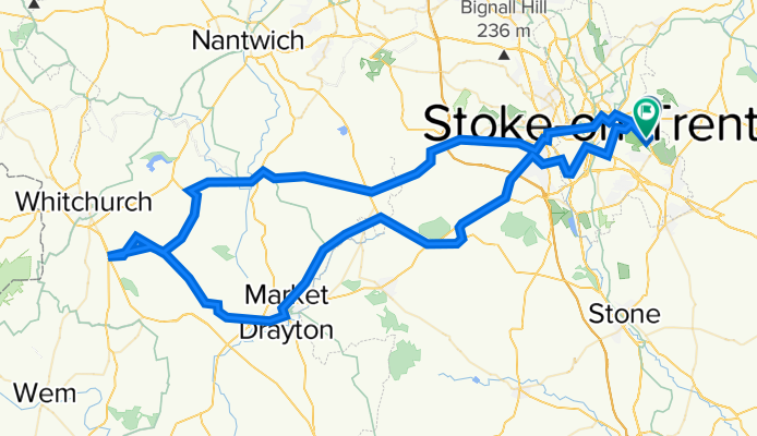
Prees
A cycling route starting in Longton, England, United Kingdom.
Overview
About this route
Night
OpenCycleMap
OpenStreetMap
Atlas
Outdoors
Landscape
Google Maps
Google Hybrid
- -:--
- Duration
- 99.5 km
- Distance
- 401 m
- Ascent
- 408 m
- Descent
- ---
- Avg. speed
- 196 m
- Max. altitude

Route quality
Waytypes & surfaces along the route
Waytypes
Road
30.1 km
(30 %)
Busy road
27.9 km
(28 %)
Surfaces
Paved
21.6 km
(22 %)
Unpaved
2.5 km
(2 %)
Asphalt
20.3 km
(20 %)
Paved (undefined)
1.3 km
(1 %)
Continue with Bikemap
Use, edit, or download this cycling route
You would like to ride Prees or customize it for your own trip? Here is what you can do with this Bikemap route:
Free features
- Save this route as favorite or in collections
- Copy & plan your own version of this route
- Split it into stages to create a multi-day tour
- Sync your route with Garmin or Wahoo
Premium features
Free trial for 3 days, or one-time payment. More about Bikemap Premium.
- Navigate this route on iOS & Android
- Export a GPX / KML file of this route
- Create your custom printout (try it for free)
- Download this route for offline navigation
Discover more Premium features.
Get Bikemap PremiumFrom our community
Other popular routes starting in Longton
 trial
trial- Distance
- 5 km
- Ascent
- 331 m
- Descent
- 455 m
- Location
- Longton, England, United Kingdom
 DMH Bike Ride 2019
- Distance
- 163.2 km
- Ascent
- 630 m
- Descent
- 629 m
- Location
- Longton, England, United Kingdom
 School Lane 39 to School Lane 19, Caverswall
- Distance
- 47.7 km
- Ascent
- 663 m
- Descent
- 664 m
- Location
- Longton, England, United Kingdom
 Railway Road, Stoke-on-Trent to A519, Stafford
- Distance
- 40 km
- Ascent
- 250 m
- Descent
- 350 m
- Location
- Longton, England, United Kingdom
 tour 2022
- Distance
- 14,829.5 km
- Ascent
- 90,959 m
- Descent
- 90,991 m
- Location
- Longton, England, United Kingdom
 Prees
Prees- Distance
- 99.5 km
- Ascent
- 401 m
- Descent
- 408 m
- Location
- Longton, England, United Kingdom
 Chatsworth Place 14 to Chatsworth Place 14
- Distance
- 7.4 km
- Ascent
- 265 m
- Descent
- 276 m
- Location
- Longton, England, United Kingdom
 Route to 2 Bogs Lane, Blythe Bridge, Stoke-on-Trent, ST11 9PH
- Distance
- 45.7 km
- Ascent
- 351 m
- Descent
- 350 m
- Location
- Longton, England, United Kingdom
Open it in the app