

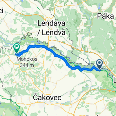
Muraszemenye (Hódvár) - Letenye (öreg híd) - Letenye (új híd) - ...._ Molnári kenukikötő
A cycling route starting in Domašinec, Međimurje County, Croatia.
Overview
About this route
- -:--
- Duration
- 30.5 km
- Distance
- 12 m
- Ascent
- 26 m
- Descent
- ---
- Avg. speed
- 150 m
- Max. altitude

Route highlights
Points of interest along the route
Point of interest after 9.1 km
Letenye (régi híd)
Point of interest after 10.2 km
M7-es híd
Point of interest after 28 km
Magasparti kikötő
Point of interest after 30.5 km
Molnári Kenukikötő
Continue with Bikemap
Use, edit, or download this cycling route
You would like to ride Muraszemenye (Hódvár) - Letenye (öreg híd) - Letenye (új híd) - ...._ Molnári kenukikötő or customize it for your own trip? Here is what you can do with this Bikemap route:
Free features
- Save this route as favorite or in collections
- Copy & plan your own version of this route
- Sync your route with Garmin or Wahoo
Premium features
Free trial for 3 days, or one-time payment. More about Bikemap Premium.
- Navigate this route on iOS & Android
- Export a GPX / KML file of this route
- Create your custom printout (try it for free)
- Download this route for offline navigation
Discover more Premium features.
Get Bikemap PremiumFrom our community
Other popular routes starting in Domašinec
 Day 16
- Distance
- 30.8 km
- Ascent
- 59 m
- Descent
- 29 m
- Location
- Domašinec, Međimurje County, Croatia
 Unnamed Road, Muraszemenye to Unnamed Road, Muraszemenye
- Distance
- 0.6 km
- Ascent
- 13 m
- Descent
- 0 m
- Location
- Domašinec, Međimurje County, Croatia
 5.8 14h15
- Distance
- 31 km
- Ascent
- 227 m
- Descent
- 122 m
- Location
- Domašinec, Međimurje County, Croatia
 cakovec-domašinec
- Distance
- 14.4 km
- Ascent
- 26 m
- Descent
- 11 m
- Location
- Domašinec, Međimurje County, Croatia
 Sredisce - Marija Bistrica
- Distance
- 197.1 km
- Ascent
- 484 m
- Descent
- 484 m
- Location
- Domašinec, Međimurje County, Croatia
 Murafölde túra / Alsószemenye (Hódvár) - Molnári
- Distance
- 29.8 km
- Ascent
- 30 m
- Descent
- 42 m
- Location
- Domašinec, Međimurje County, Croatia
 Domašinec-Prelog-Domašinec
- Distance
- 31 km
- Ascent
- 34 m
- Descent
- 37 m
- Location
- Domašinec, Međimurje County, Croatia
 Bringán-vízen könnyedén
- Distance
- 44.9 km
- Ascent
- 270 m
- Descent
- 268 m
- Location
- Domašinec, Međimurje County, Croatia
Open it in the app