

Overview
About this route
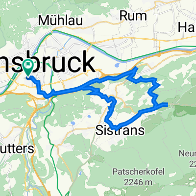
Inn und Etschradweg 2007
- -:--
- Duration
- 62.4 km
- Distance
- 220 m
- Ascent
- 79 m
- Descent
- ---
- Avg. speed
- 731 m
- Max. altitude

Part of
Inn / Etschradweg 2007
5 stages
Route quality
Waytypes & surfaces along the route
Waytypes
Track
31.2 km
(50 %)
Cycleway
14.3 km
(23 %)
Surfaces
Paved
59.2 km
(95 %)
Unpaved
2.5 km
(4 %)
Asphalt
59.2 km
(95 %)
Pebblestone
1.2 km
(2 %)
Route highlights
Points of interest along the route
Point of interest after 62.4 km
Gasthof Neuner
Continue with Bikemap
Use, edit, or download this cycling route
You would like to ride Innsbruck - Imst or customize it for your own trip? Here is what you can do with this Bikemap route:
Free features
- Save this route as favorite or in collections
- Copy & plan your own version of this route
- Sync your route with Garmin or Wahoo
Premium features
Free trial for 3 days, or one-time payment. More about Bikemap Premium.
- Navigate this route on iOS & Android
- Export a GPX / KML file of this route
- Create your custom printout (try it for free)
- Download this route for offline navigation
Discover more Premium features.
Get Bikemap PremiumFrom our community
Other popular routes starting in Innsbruck
 Innsbruck / Zirl / Magdeburger Hüttn / Kranebitten
- Distance
- 52.2 km
- Ascent
- 1,200 m
- Descent
- 1,199 m
- Location
- Innsbruck, Tyrol, Austria
 Nockspitz-Überschreitung
- Distance
- 54 km
- Ascent
- 2,398 m
- Descent
- 2,385 m
- Location
- Innsbruck, Tyrol, Austria
 Wiesenhöfe - Sistrans - Aldrans - Innsbruck
- Distance
- 22.2 km
- Ascent
- 452 m
- Descent
- 450 m
- Location
- Innsbruck, Tyrol, Austria
 Lange Ausfahrt durch Innsbruck
- Distance
- 46.3 km
- Ascent
- 68 m
- Descent
- 67 m
- Location
- Innsbruck, Tyrol, Austria
 Am Roßsprung 1, Innsbruck nach Am Roßsprung 1, Innsbruck
- Distance
- 40 km
- Ascent
- 622 m
- Descent
- 674 m
- Location
- Innsbruck, Tyrol, Austria
 IBK - Maria Waldrast - IBK
- Distance
- 62.1 km
- Ascent
- 1,628 m
- Descent
- 1,626 m
- Location
- Innsbruck, Tyrol, Austria
 Stockerhof-Runde
- Distance
- 26.4 km
- Ascent
- 874 m
- Descent
- 875 m
- Location
- Innsbruck, Tyrol, Austria
 IBK-Axamer Lizum-IBK
- Distance
- 46.6 km
- Ascent
- 1,175 m
- Descent
- 1,178 m
- Location
- Innsbruck, Tyrol, Austria
Open it in the app