

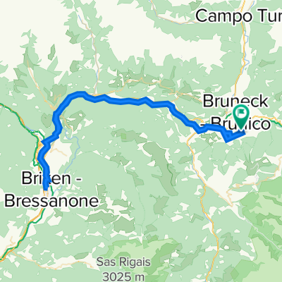
Schmetterlingsroute - Reischach - St.Sigmund - Hofern - Issing - Bruneck
A cycling route starting in Riscone, Trentino-Alto Adige, Italy.
Overview
About this route
Interessante abwechslungsreiche Strecke
ab Gisser (St.Sigmund ) 8 Km stark ansteigend - restliche Strecke ein leichtes
auf und ab
Pfalzen ab Fernwärmewerk Weg Nr 17 bis Lothen+
Gesamtlänge 40 Km
Aufstiegshöhe gesamt ca. 900mt
Fahrtzeit 2,5 -3 Std.
- -:--
- Duration
- 38.7 km
- Distance
- 860 m
- Ascent
- 857 m
- Descent
- ---
- Avg. speed
- ---
- Max. altitude
Continue with Bikemap
Use, edit, or download this cycling route
You would like to ride Schmetterlingsroute - Reischach - St.Sigmund - Hofern - Issing - Bruneck or customize it for your own trip? Here is what you can do with this Bikemap route:
Free features
- Save this route as favorite or in collections
- Copy & plan your own version of this route
- Sync your route with Garmin or Wahoo
Premium features
Free trial for 3 days, or one-time payment. More about Bikemap Premium.
- Navigate this route on iOS & Android
- Export a GPX / KML file of this route
- Create your custom printout (try it for free)
- Download this route for offline navigation
Discover more Premium features.
Get Bikemap PremiumFrom our community
Other popular routes starting in Riscone
 Plan de Korones-Passo Stalle-Plan de Korones
- Distance
- 66.9 km
- Ascent
- 1,609 m
- Descent
- 1,597 m
- Location
- Riscone, Trentino-Alto Adige, Italy
 Schnelle Radrunde von Friedersreuth nach Olang kronplatz
- Distance
- 27.5 km
- Ascent
- 1,065 m
- Descent
- 661 m
- Location
- Riscone, Trentino-Alto Adige, Italy
 Reischach - Brixen und zurück
- Distance
- 75.1 km
- Ascent
- 587 m
- Descent
- 589 m
- Location
- Riscone, Trentino-Alto Adige, Italy
 Bruneck - Fanes / Lavarella
- Distance
- 41.2 km
- Ascent
- 2,268 m
- Descent
- 1,184 m
- Location
- Riscone, Trentino-Alto Adige, Italy
 plan de corones
- Distance
- 14.3 km
- Ascent
- 3,166 m
- Descent
- 1,850 m
- Location
- Riscone, Trentino-Alto Adige, Italy
 Freeride - Kronplatz-Furcia
- Distance
- 4.5 km
- Ascent
- 0 m
- Descent
- 519 m
- Location
- Riscone, Trentino-Alto Adige, Italy
 Kronplatzumrundung...
- Distance
- 43.4 km
- Ascent
- 1,352 m
- Descent
- 1,349 m
- Location
- Riscone, Trentino-Alto Adige, Italy
 Schmetterlingsroute - Reischach - St.Sigmund - Hofern - Issing - Bruneck
- Distance
- 38.7 km
- Ascent
- 860 m
- Descent
- 857 m
- Location
- Riscone, Trentino-Alto Adige, Italy
Open it in the app