
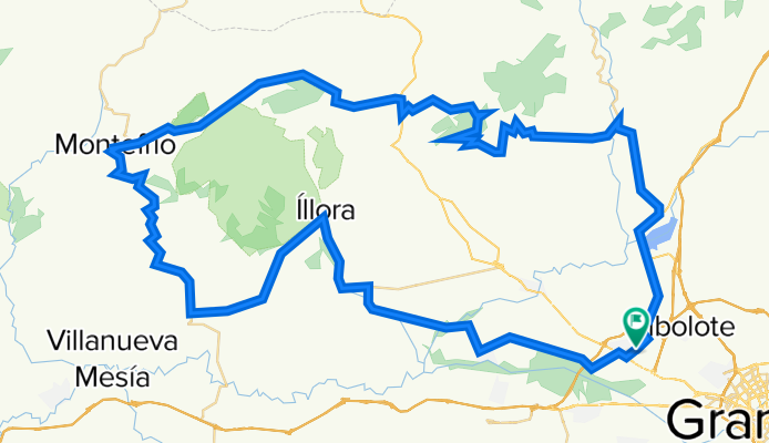
Atarfe Illora Montefrio Olivares
A cycling route starting in Atarfe, Andalusia, Spain.
Overview
About this route
Ruta paara hacer en bicicleta de carretera
- -:--
- Duration
- 108 km
- Distance
- 1,256 m
- Ascent
- 1,254 m
- Descent
- ---
- Avg. speed
- 1,033 m
- Max. altitude

Route quality
Waytypes & surfaces along the route
Waytypes
Road
71 km
(66 %)
Busy road
28.8 km
(27 %)
Surfaces
Paved
98.7 km
(91 %)
Unpaved
0.1 km
(<1 %)
Asphalt
98.5 km
(91 %)
Gravel
0.1 km
(<1 %)
Continue with Bikemap
Use, edit, or download this cycling route
You would like to ride Atarfe Illora Montefrio Olivares or customize it for your own trip? Here is what you can do with this Bikemap route:
Free features
- Save this route as favorite or in collections
- Copy & plan your own version of this route
- Split it into stages to create a multi-day tour
- Sync your route with Garmin or Wahoo
Premium features
Free trial for 3 days, or one-time payment. More about Bikemap Premium.
- Navigate this route on iOS & Android
- Export a GPX / KML file of this route
- Create your custom printout (try it for free)
- Download this route for offline navigation
Discover more Premium features.
Get Bikemap PremiumFrom our community
Other popular routes starting in Atarfe
 Llano de la Perdiz, gracias Aguilera ^^.
- Distance
- 26.8 km
- Ascent
- 569 m
- Descent
- 295 m
- Location
- Atarfe, Andalusia, Spain
 Atarfe - Cogollos - Atarfe
- Distance
- 44.6 km
- Ascent
- 547 m
- Descent
- 547 m
- Location
- Atarfe, Andalusia, Spain
 Atarfe- Vega de Granada
- Distance
- 45.5 km
- Ascent
- 207 m
- Descent
- 207 m
- Location
- Atarfe, Andalusia, Spain
 Atarfe Illora Montefrio Olivares
- Distance
- 108 km
- Ascent
- 1,256 m
- Descent
- 1,254 m
- Location
- Atarfe, Andalusia, Spain
 A Zagra y Montefrío
- Distance
- 131.6 km
- Ascent
- 1,153 m
- Descent
- 1,148 m
- Location
- Atarfe, Andalusia, Spain
 Caparacena - Berbe- Cauro - Limones - Moclín
- Distance
- 77.5 km
- Ascent
- 1,111 m
- Descent
- 1,112 m
- Location
- Atarfe, Andalusia, Spain
 Atarfe-Pantano Cubillas-Maracanilla-Moleona-Atarfe
- Distance
- 32.2 km
- Ascent
- 364 m
- Descent
- 364 m
- Location
- Atarfe, Andalusia, Spain
 Atarfe - Cogollos - Puerto Lobo - Atarfe
- Distance
- 68.1 km
- Ascent
- 1,117 m
- Descent
- 1,117 m
- Location
- Atarfe, Andalusia, Spain
Open it in the app