

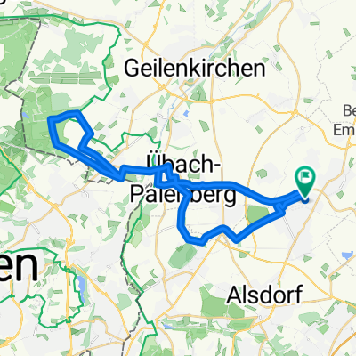
St Vith
A cycling route starting in Baesweiler, North Rhine-Westphalia, Germany.
Overview
About this route
- -:--
- Duration
- 107.3 km
- Distance
- 683 m
- Ascent
- 360 m
- Descent
- ---
- Avg. speed
- 569 m
- Max. altitude

Route quality
Waytypes & surfaces along the route
Waytypes
Path
47.7 km
(44 %)
Cycleway
36.4 km
(34 %)
Surfaces
Paved
96.1 km
(90 %)
Unpaved
1.6 km
(1 %)
Asphalt
91.4 km
(85 %)
Paving stones
1.8 km
(2 %)
Continue with Bikemap
Use, edit, or download this cycling route
You would like to ride St Vith or customize it for your own trip? Here is what you can do with this Bikemap route:
Free features
- Save this route as favorite or in collections
- Copy & plan your own version of this route
- Split it into stages to create a multi-day tour
- Sync your route with Garmin or Wahoo
Premium features
Free trial for 3 days, or one-time payment. More about Bikemap Premium.
- Navigate this route on iOS & Android
- Export a GPX / KML file of this route
- Create your custom printout (try it for free)
- Download this route for offline navigation
Discover more Premium features.
Get Bikemap PremiumFrom our community
Other popular routes starting in Baesweiler
 sonntagstour
- Distance
- 68.3 km
- Ascent
- 136 m
- Descent
- 123 m
- Location
- Baesweiler, North Rhine-Westphalia, Germany
 Baesweiler Tevener Heide
- Distance
- 31.8 km
- Ascent
- 144 m
- Descent
- 146 m
- Location
- Baesweiler, North Rhine-Westphalia, Germany
 2017 Blausteinsee Aktifurlaub
- Distance
- 34 km
- Ascent
- 85 m
- Descent
- 101 m
- Location
- Baesweiler, North Rhine-Westphalia, Germany
 Ca.drei Stunden
- Distance
- 72 km
- Ascent
- 475 m
- Descent
- 423 m
- Location
- Baesweiler, North Rhine-Westphalia, Germany
 St Vith
- Distance
- 107.3 km
- Ascent
- 683 m
- Descent
- 360 m
- Location
- Baesweiler, North Rhine-Westphalia, Germany
 Sonntagsrunde von winy
- Distance
- 69.6 km
- Ascent
- 420 m
- Descent
- 426 m
- Location
- Baesweiler, North Rhine-Westphalia, Germany
 Sonntags Route
- Distance
- 24 km
- Ascent
- 81 m
- Descent
- 81 m
- Location
- Baesweiler, North Rhine-Westphalia, Germany
 Übach - Sophienhöhe - Übach # 57km # 22.6.2016
- Distance
- 57.6 km
- Ascent
- 305 m
- Descent
- 304 m
- Location
- Baesweiler, North Rhine-Westphalia, Germany
Open it in the app