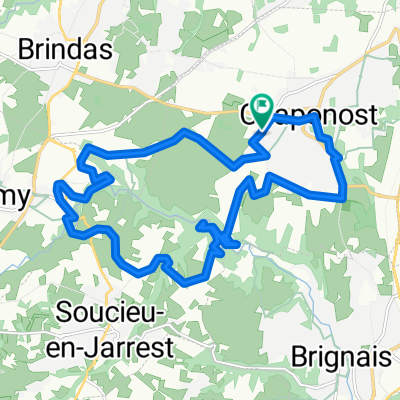
Col des brosses (malval et luere)
A cycling route starting in Chaponost, Auvergne-Rh么ne-Alpes, France.
Overview
About this route
Climb of the Col des Brosses, carrying momentum from the descent, passing the Col de Malval, and a "slide" on the Lu猫re. Nice descent to Chaponost.
- -:--
- Duration
- 51.4 km
- Distance
- 773 m
- Ascent
- 773 m
- Descent
- ---
- Avg. speed
- ---
- Max. altitude
Continue with Bikemap
Use, edit, or download this cycling route
You would like to ride Col des brosses (malval et luere) or customize it for your own trip? Here is what you can do with this Bikemap route:
Free features
- Save this route as favorite or in collections
- Copy & plan your own version of this route
- Sync your route with Garmin or Wahoo
Premium features
Free trial for 3 days, or one-time payment. More about Bikemap Premium.
- Navigate this route on iOS & Android
- Export a GPX / KML file of this route
- Create your custom printout (try it for free)
- Download this route for offline navigation
Discover more Premium features.
Get Bikemap PremiumFrom our community
Other popular routes starting in Chaponost
- De 20 Avenue Paul Doumer, Chaponost 脿 46 Chemin de la Lande, Brignais
- Distance
- 3.6 km
- Ascent
- 13 m
- Descent
- 85 m
- Location
- Chaponost, Auvergne-Rh么ne-Alpes, France
- 04892-1101-Chaponost-Thurins-Courzieu-Vaugneray-Brindas-Chaponost
- Distance
- 47.1 km
- Ascent
- 1,269 m
- Descent
- 1,277 m
- Location
- Chaponost, Auvergne-Rh么ne-Alpes, France
- Route de Brignais, Saint-Genis-Laval 脿 Avenue Guy-de-Collongue, 脡cully
- Distance
- 12.9 km
- Ascent
- 207 m
- Descent
- 167 m
- Location
- Chaponost, Auvergne-Rh么ne-Alpes, France
- Route茅troite 脿 Chemin du Tronchil1
- Distance
- 42.6 km
- Ascent
- 924 m
- Descent
- 830 m
- Location
- Chaponost, Auvergne-Rh么ne-Alpes, France
- 52 Chemin de Combarembert, Chaponost 脿 523 Cours du Troisi猫me Mill茅naire, Saint-Priest
- Distance
- 22.9 km
- Ascent
- 166 m
- Descent
- 270 m
- Location
- Chaponost, Auvergne-Rh么ne-Alpes, France
- Chaponost - Parcours sportif du soir - 26384 - UtagawaVTT.com
- Distance
- 18.8 km
- Ascent
- 340 m
- Descent
- 340 m
- Location
- Chaponost, Auvergne-Rh么ne-Alpes, France
- 05319-0825-Chaponost-Brindas-LaTourDeSalvagny-SteConsorce-StLaurentDeVaux-Messimy-Brindas-Chaponost
- Distance
- 51.8 km
- Ascent
- 881 m
- Descent
- 782 m
- Location
- Chaponost, Auvergne-Rh么ne-Alpes, France
- 05684-0829-Chaponost-Brindas-StLaurentDeVaux-Yzeron-StMartinEnHaut-LaChevre-Thurins-Brindas-Chaponost
- Distance
- 55.1 km
- Ascent
- 1,079 m
- Descent
- 1,091 m
- Location
- Chaponost, Auvergne-Rh么ne-Alpes, France
Open it in the app