

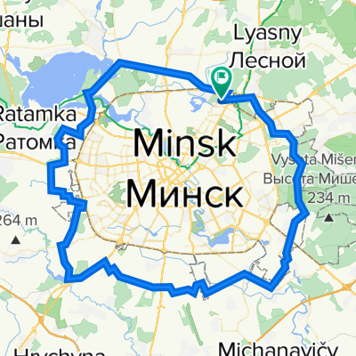
Вокруг МКАД (оптимизированный маршрут)
A cycling route starting in Bal’shavik, Minsk Region, Belarus.
Overview
About this route
- 5 h 29 min
- Duration
- 95.3 km
- Distance
- 174 m
- Ascent
- 253 m
- Descent
- 17.4 km/h
- Avg. speed
- ---
- Max. altitude

Route quality
Waytypes & surfaces along the route
Waytypes
Road
22.7 km
(24 %)
Pedestrian area
22.5 km
(24 %)
Surfaces
Paved
58.3 km
(61 %)
Unpaved
15.2 km
(16 %)
Asphalt
56 km
(59 %)
Gravel
8.9 km
(9 %)
Continue with Bikemap
Use, edit, or download this cycling route
You would like to ride Вокруг МКАД (оптимизированный маршрут) or customize it for your own trip? Here is what you can do with this Bikemap route:
Free features
- Save this route as favorite or in collections
- Copy & plan your own version of this route
- Split it into stages to create a multi-day tour
- Sync your route with Garmin or Wahoo
Premium features
Free trial for 3 days, or one-time payment. More about Bikemap Premium.
- Navigate this route on iOS & Android
- Export a GPX / KML file of this route
- Create your custom printout (try it for free)
- Download this route for offline navigation
Discover more Premium features.
Get Bikemap PremiumFrom our community
Other popular routes starting in Bal’shavik
 Маршрут 22-048. Северо-западные леса Минского района, дача Быкова, Слаломный канал.
- Distance
- 41.7 km
- Ascent
- 367 m
- Descent
- 391 m
- Location
- Bal’shavik, Minsk Region, Belarus
 Маршрут 22-021. Поездка до края аэропорта Минск2 (слишком много бездорожья)
- Distance
- 71.2 km
- Ascent
- 647 m
- Descent
- 651 m
- Location
- Bal’shavik, Minsk Region, Belarus
 Маршрут 12. Северный район Минска, вокруг Вячи.
- Distance
- 54.4 km
- Ascent
- 100 m
- Descent
- 152 m
- Location
- Bal’shavik, Minsk Region, Belarus
 Выезд 23-31. ЗЛ, Дроздово, Боровляны,ЗЛ.
- Distance
- 18.5 km
- Ascent
- 213 m
- Descent
- 212 m
- Location
- Bal’shavik, Minsk Region, Belarus
 Вокруг МКАД (оптимизированный маршрут)
- Distance
- 95.3 km
- Ascent
- 174 m
- Descent
- 253 m
- Location
- Bal’shavik, Minsk Region, Belarus
 Выезд 23-38. Северные водохранилища: Дубровское, Острошицкое, Вяча.
- Distance
- 53.3 km
- Ascent
- 558 m
- Descent
- 559 m
- Location
- Bal’shavik, Minsk Region, Belarus
 Выезд 24-05. Вокруг Чижовского водохранилища.
- Distance
- 39.7 km
- Ascent
- 411 m
- Descent
- 395 m
- Location
- Bal’shavik, Minsk Region, Belarus
 Маршрут 22-104. Зимние Цнянские восьмёрки.
- Distance
- 12.8 km
- Ascent
- 74 m
- Descent
- 72 m
- Location
- Bal’shavik, Minsk Region, Belarus
Open it in the app