

PeñaMorena-CruzPedroAlamo
A cycling route starting in Peguerinos, Castille and León, Spain.
Overview
About this route
N/A
- -:--
- Duration
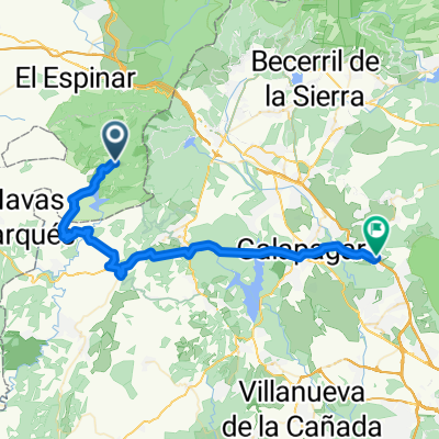
- 12.2 km
- Distance
- 488 m
- Ascent
- 439 m
- Descent
- ---
- Avg. speed
- 1,768 m
- Max. altitude

Route highlights
Points of interest along the route
Drinking water after 1.9 km
Fuente A. Heras
Drinking water after 3 km
Fuente de El Esportón
Point of interest after 3.3 km
Collado de las Lagunas
Point of interest after 4.2 km
Peñón de la Solana
Point of interest after 5.2 km
Cruz de Pedro Álamo
Drinking water after 8.1 km
Manantial de los Lagos
Drinking water after 9.7 km
Fuente de los Arteseros
Continue with Bikemap
Use, edit, or download this cycling route
You would like to ride PeñaMorena-CruzPedroAlamo or customize it for your own trip? Here is what you can do with this Bikemap route:
Free features
- Save this route as favorite or in collections
- Copy & plan your own version of this route
- Sync your route with Garmin or Wahoo
Premium features
Free trial for 3 days, or one-time payment. More about Bikemap Premium.
- Navigate this route on iOS & Android
- Export a GPX / KML file of this route
- Create your custom printout (try it for free)
- Download this route for offline navigation
Discover more Premium features.
Get Bikemap PremiumFrom our community
Other popular routes starting in Peguerinos
 PeñaMorena-CruzPedroAlamo
- Distance
- 12.2 km
- Ascent
- 488 m
- Descent
- 439 m
- Location
- Peguerinos, Castille and León, Spain
 San Rafael-Camping Valle Enmedio-Senda del Ingeniero
- Distance
- 36 km
- Ascent
- 834 m
- Descent
- 835 m
- Location
- Peguerinos, Castille and León, Spain
 6 Peguerinos- Aerodromo Fuentemilanos
- Distance
- 46.5 km
- Ascent
- 570 m
- Descent
- 907 m
- Location
- Peguerinos, Castille and León, Spain
 Ruta al pantano
- Distance
- 4.2 km
- Ascent
- 145 m
- Descent
- 279 m
- Location
- Peguerinos, Castille and León, Spain
 peguerinos parriba
- Distance
- 11.2 km
- Ascent
- 334 m
- Descent
- 148 m
- Location
- Peguerinos, Castille and León, Spain
 Peguerinos-Torrelodones
- Distance
- 48.3 km
- Ascent
- 510 m
- Descent
- 1,091 m
- Location
- Peguerinos, Castille and León, Spain
 Peguerinos to Valle de los Callidos
- Distance
- 79 km
- Ascent
- 1,768 m
- Descent
- 1,768 m
- Location
- Peguerinos, Castille and León, Spain
 Abantos desde el Valle de Enmedio
- Distance
- 26.3 km
- Ascent
- 571 m
- Descent
- 569 m
- Location
- Peguerinos, Castille and León, Spain
Open it in the app