

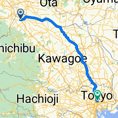
1423, Yatsutajimamachi, Isesaki to 400, Toriyamashimocho, Ota
A cycling route starting in Honjō, Saitama, Japan.
Overview
About this route
- 1 h 12 min
- Duration
- 21 km
- Distance
- 80 m
- Ascent
- 83 m
- Descent
- 17.6 km/h
- Avg. speed
- ---
- Max. altitude

Continue with Bikemap
Use, edit, or download this cycling route
You would like to ride 1423, Yatsutajimamachi, Isesaki to 400, Toriyamashimocho, Ota or customize it for your own trip? Here is what you can do with this Bikemap route:
Free features
- Save this route as favorite or in collections
- Copy & plan your own version of this route
- Sync your route with Garmin or Wahoo
Premium features
Free trial for 3 days, or one-time payment. More about Bikemap Premium.
- Navigate this route on iOS & Android
- Export a GPX / KML file of this route
- Create your custom printout (try it for free)
- Download this route for offline navigation
Discover more Premium features.
Get Bikemap PremiumFrom our community
Other popular routes starting in Honjō
 272, Nishida, Fukaya to 38-81, Kumanocho, Ota
- Distance
- 28.2 km
- Ascent
- 71 m
- Descent
- 59 m
- Location
- Honjō, Saitama, Japan
 御荷鉾スーパー林道(本庄~下仁田)
- Distance
- 107.4 km
- Ascent
- 4,875 m
- Descent
- 4,681 m
- Location
- Honjō, Saitama, Japan
 320-7, Nishida, Fukaya to 2-33, Higashidai 5-Chōme, Honjo
- Distance
- 4 km
- Ascent
- 16 m
- Descent
- 16 m
- Location
- Honjō, Saitama, Japan
 3-chōme 9, Honjo to Kyoto Shiyakusho-mae Station
- Distance
- 449.7 km
- Ascent
- 5,870 m
- Descent
- 5,874 m
- Location
- Honjō, Saitama, Japan
 本庄ー田園調布
- Distance
- 112.2 km
- Ascent
- 279 m
- Descent
- 300 m
- Location
- Honjō, Saitama, Japan
 中山道の宿場町、本庄ルート(本庄市ルート)
- Distance
- 19.8 km
- Ascent
- 48 m
- Descent
- 51 m
- Location
- Honjō, Saitama, Japan
 84 児玉郡市周遊ルート
- Distance
- 74.6 km
- Ascent
- 657 m
- Descent
- 660 m
- Location
- Honjō, Saitama, Japan
 七本木, 上里町へ外神田2丁目, 千代田区
- Distance
- 109.1 km
- Ascent
- 224 m
- Descent
- 267 m
- Location
- Honjō, Saitama, Japan
Open it in the app