

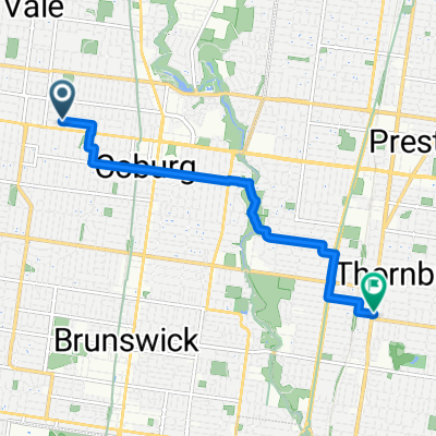
Thornbury-Bundoora Park and Farm from Tonys
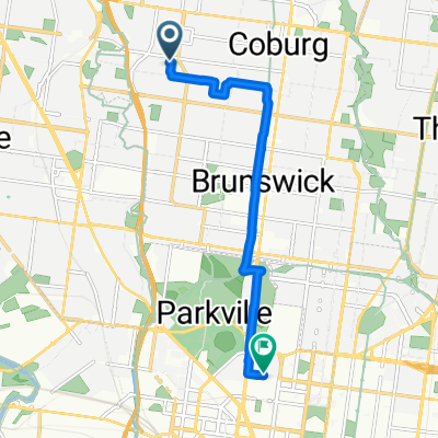
A cycling route starting in Pascoe Vale South, Victoria, Australia.
Overview
About this route
- -:--
- Duration
- 19.6 km
- Distance
- 119 m
- Ascent
- 67 m
- Descent
- ---
- Avg. speed
- 112 m
- Max. altitude

Route quality
Waytypes & surfaces along the route
Waytypes
Cycleway
8.5 km
(43 %)
Road
8 km
(41 %)
Surfaces
Paved
19.4 km
(99 %)
Concrete
8.2 km
(42 %)
Asphalt
7.1 km
(36 %)
Continue with Bikemap
Use, edit, or download this cycling route
You would like to ride Thornbury-Bundoora Park and Farm from Tonys or customize it for your own trip? Here is what you can do with this Bikemap route:
Free features
- Save this route as favorite or in collections
- Copy & plan your own version of this route
- Sync your route with Garmin or Wahoo
Premium features
Free trial for 3 days, or one-time payment. More about Bikemap Premium.
- Navigate this route on iOS & Android
- Export a GPX / KML file of this route
- Create your custom printout (try it for free)
- Download this route for offline navigation
Discover more Premium features.
Get Bikemap PremiumFrom our community
Other popular routes starting in Pascoe Vale South
 Pascoe Vale South to Camberwell
- Distance
- 27.4 km
- Ascent
- 217 m
- Descent
- 177 m
- Location
- Pascoe Vale South, Victoria, Australia
 home-school
- Distance
- 8.6 km
- Ascent
- 47 m
- Descent
- 47 m
- Location
- Pascoe Vale South, Victoria, Australia
 55 Soudan Street, Coburg to 564 High Street, Thornbury
- Distance
- 6.6 km
- Ascent
- 34 m
- Descent
- 40 m
- Location
- Pascoe Vale South, Victoria, Australia
 maribyrnong River/Moonee ponds Creek.
- Distance
- 22.9 km
- Ascent
- 175 m
- Descent
- 172 m
- Location
- Pascoe Vale South, Victoria, Australia
 Pacoe-Watergardens
- Distance
- 34 km
- Ascent
- 265 m
- Descent
- 265 m
- Location
- Pascoe Vale South, Victoria, Australia
 home to work
- Distance
- 12.1 km
- Ascent
- 37 m
- Descent
- 56 m
- Location
- Pascoe Vale South, Victoria, Australia
 51 Hawthorn St, Coburg to 187 Cooper St, Epping
- Distance
- 19.9 km
- Ascent
- 106 m
- Descent
- 38 m
- Location
- Pascoe Vale South, Victoria, Australia
 Moderate route in Melbourne
- Distance
- 12.2 km
- Ascent
- 23 m
- Descent
- 91 m
- Location
- Pascoe Vale South, Victoria, Australia
Open it in the app