

Wartenberg Tour/Camel Hills
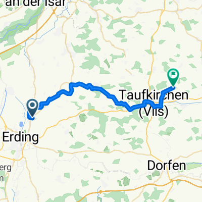
A cycling route starting in Erding, Bavaria, Germany.
Overview
About this route
- -:--
- Duration
- 47.2 km
- Distance
- 261 m
- Ascent
- 266 m
- Descent
- ---
- Avg. speed
- ---
- Max. altitude
Route quality
Waytypes & surfaces along the route
Waytypes
Track
25.5 km
(54 %)
Quiet road
8 km
(17 %)
Surfaces
Paved
19.8 km
(42 %)
Unpaved
25.9 km
(55 %)
Asphalt
17.5 km
(37 %)
Gravel
13.2 km
(28 %)
Continue with Bikemap
Use, edit, or download this cycling route
You would like to ride Wartenberg Tour/Camel Hills or customize it for your own trip? Here is what you can do with this Bikemap route:
Free features
- Save this route as favorite or in collections
- Copy & plan your own version of this route
- Sync your route with Garmin or Wahoo
Premium features
Free trial for 3 days, or one-time payment. More about Bikemap Premium.
- Navigate this route on iOS & Android
- Export a GPX / KML file of this route
- Create your custom printout (try it for free)
- Download this route for offline navigation
Discover more Premium features.
Get Bikemap PremiumFrom our community
Other popular routes starting in Erding
 MTB Eschlbach
- Distance
- 31 km
- Ascent
- 209 m
- Descent
- 210 m
- Location
- Erding, Bavaria, Germany
 Trainingstour 1
- Distance
- 43.2 km
- Ascent
- 143 m
- Descent
- 143 m
- Location
- Erding, Bavaria, Germany
 Erding-Eitting
- Distance
- 64.7 km
- Ascent
- 103 m
- Descent
- 99 m
- Location
- Erding, Bavaria, Germany
 Am Weiher nach Geislbach
- Distance
- 27.5 km
- Ascent
- 222 m
- Descent
- 193 m
- Location
- Erding, Bavaria, Germany
 ED mit Kirchberg 60km
- Distance
- 60 km
- Ascent
- 321 m
- Descent
- 321 m
- Location
- Erding, Bavaria, Germany
 sonntags kurz
- Distance
- 34.7 km
- Ascent
- 116 m
- Descent
- 117 m
- Location
- Erding, Bavaria, Germany
 Rund um den Ebersberger Forst
- Distance
- 90.3 km
- Ascent
- 346 m
- Descent
- 346 m
- Location
- Erding, Bavaria, Germany
 Mariabrunn
- Distance
- 103.3 km
- Ascent
- 470 m
- Descent
- 472 m
- Location
- Erding, Bavaria, Germany
Open it in the app