Brno-Vrutky
A cycling route starting in Brno, South Moravian, Czechia.
Overview
About this route
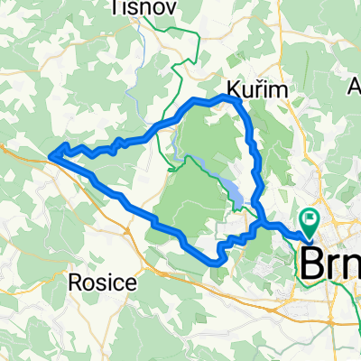
Brno-Vrutky (via UH, BN, PD)
- -:--
- Duration
- 248.5 km
- Distance
- 1,445 m
- Ascent
- 1,268 m
- Descent
- ---
- Avg. speed
- ---
- Max. altitude
Route quality
Waytypes & surfaces along the route
Waytypes
Busy road
187.3 km
(75 %)
Road
23.1 km
(9 %)
Surfaces
Paved
193.3 km
(78 %)
Unpaved
3 km
(1 %)
Asphalt
186.3 km
(75 %)
Concrete
3.6 km
(1 %)
Continue with Bikemap
Use, edit, or download this cycling route
You would like to ride Brno-Vrutky or customize it for your own trip? Here is what you can do with this Bikemap route:
Free features
- Save this route as favorite or in collections
- Copy & plan your own version of this route
- Split it into stages to create a multi-day tour
- Sync your route with Garmin or Wahoo
Premium features
Free trial for 3 days, or one-time payment. More about Bikemap Premium.
- Navigate this route on iOS & Android
- Export a GPX / KML file of this route
- Create your custom printout (try it for free)
- Download this route for offline navigation
Discover more Premium features.
Get Bikemap PremiumFrom our community
Other popular routes starting in Brno
- Brno, Anenská - Bohunice a zpět, pěšky
- Distance
- 11.5 km
- Ascent
- 152 m
- Descent
- 152 m
- Location
- Brno, South Moravian, Czechia
- Židenice-Bílovice n/S-Mariánske údolí-Stránská skála-Židenice
- Distance
- 33.2 km
- Ascent
- 394 m
- Descent
- 394 m
- Location
- Brno, South Moravian, Czechia
- Zimní Mariánské údolí a Mokerská hájovna
- Distance
- 31.3 km
- Ascent
- 353 m
- Descent
- 353 m
- Location
- Brno, South Moravian, Czechia
- Kr.Pole-Soběšice - Mokrá Hora - Kr.Pole
- Distance
- 15.7 km
- Ascent
- 214 m
- Descent
- 214 m
- Location
- Brno, South Moravian, Czechia
- Brno - Dukovany - Mor. Krumlov - Brno
- Distance
- 114.7 km
- Ascent
- 986 m
- Descent
- 986 m
- Location
- Brno, South Moravian, Czechia
- Brno-North #1
- Distance
- 46.2 km
- Ascent
- 506 m
- Descent
- 506 m
- Location
- Brno, South Moravian, Czechia
- Židenice - Šumbera - Ochoz - Mariánské údolí - Židenice
- Distance
- 30.6 km
- Ascent
- 365 m
- Descent
- 365 m
- Location
- Brno, South Moravian, Czechia
- Brno-Přehrada-Veveří-Brno
- Distance
- 30.2 km
- Ascent
- 339 m
- Descent
- 341 m
- Location
- Brno, South Moravian, Czechia
Open it in the app