

CARRETERA 14-11-2021
A cycling route starting in Écija, Andalusia, Spain.
Overview
About this route
0
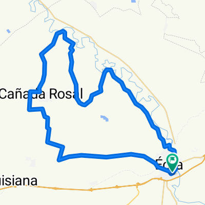
ECIJA - LOS VISOS - LA MONTIELA - SANTAELLA - LA GUIJARROSA - LA PAZ - LA CARLOTA - FUENCUBIERTA - FUENTE PALMERA - ECIJA
- -:--
- Duration
- 83.2 km
- Distance
- 645 m
- Ascent
- 647 m
- Descent
- ---
- Avg. speed
- 298 m
- Max. altitude
Francisco Javier Vega Ponce
created this 4 years ago
Route quality
Waytypes & surfaces along the route
Waytypes
Road
46.6 km
56 %
Quiet road
2.5 km
3 %
Undefined
34.1 km
41 %
Surfaces
Paved
30.8 km
(37 %)
Asphalt
30.8 km
37 %
Undefined
52.4 km
63 %
Continue with Bikemap
Use, edit, or download this cycling route
You would like to ride CARRETERA 14-11-2021 or customize it for your own trip? Here is what you can do with this Bikemap route:
Free features
- Save this route as favorite or in collections
- Copy & plan your own version of this route
- Split it into stages to create a multi-day tour
- Sync your route with Garmin or Wahoo
Premium features
Free trial for 3 days, or one-time payment. More about Bikemap Premium.
- Navigate this route on iOS & Android
- Export a GPX / KML file of this route
- Create your custom printout (try it for free)
- Download this route for offline navigation
Discover more Premium features.
Get Bikemap PremiumFrom our community
Other popular routes starting in Écija
- RUTA GRV 1. Caminos "puesta en riego" - Palomarejo - Ctra del "vecinal".0
- 45.6 km
- 315 m
- 296 m
- Écija, Andalusia, Spain


Open it in the app