

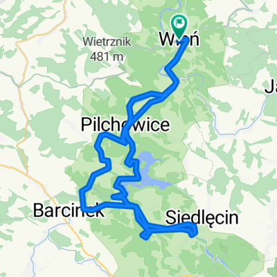
trasa wleń-klecza-radomice-pilchowice- czernica- wleń.
A cycling route starting in Wleń, Lower Silesian Voivodeship, Poland.
Overview
About this route
Polecam. Kilka mocnych podjazdów ale także kilka szybkich zjazdów. Drogi żadko uczęszczane przez samochody więc dobrze się jeździ. Po drodze możemy zobaczyć nieczynny już kamieniołom w Radomicach oraz zaporę wodną w Pilchowicach.
- -:--
- Duration
- 26.9 km
- Distance
- 456 m
- Ascent
- 459 m
- Descent
- ---
- Avg. speed
- ---
- Max. altitude

Route quality
Waytypes & surfaces along the route
Waytypes
Road
20.4 km
(76 %)
Quiet road
4.3 km
(16 %)
Surfaces
Paved
11.7 km
(44 %)
Unpaved
0.9 km
(3 %)
Asphalt
11.4 km
(43 %)
Unpaved (undefined)
0.7 km
(3 %)
Continue with Bikemap
Use, edit, or download this cycling route
You would like to ride trasa wleń-klecza-radomice-pilchowice- czernica- wleń. or customize it for your own trip? Here is what you can do with this Bikemap route:
Free features
- Save this route as favorite or in collections
- Copy & plan your own version of this route
- Sync your route with Garmin or Wahoo
Premium features
Free trial for 3 days, or one-time payment. More about Bikemap Premium.
- Navigate this route on iOS & Android
- Export a GPX / KML file of this route
- Create your custom printout (try it for free)
- Download this route for offline navigation
Discover more Premium features.
Get Bikemap PremiumFrom our community
Other popular routes starting in Wleń
 trasa wleń-klecza-radomice-pilchowice- czernica- wleń.
- Distance
- 26.9 km
- Ascent
- 456 m
- Descent
- 459 m
- Location
- Wleń, Lower Silesian Voivodeship, Poland
 Riesengebirgsvorland
- Distance
- 99.3 km
- Ascent
- 1,062 m
- Descent
- 1,078 m
- Location
- Wleń, Lower Silesian Voivodeship, Poland
 Dolina Bobru
- Distance
- 40.6 km
- Ascent
- 492 m
- Descent
- 492 m
- Location
- Wleń, Lower Silesian Voivodeship, Poland
 Maciejowiec_4
- Distance
- 75.5 km
- Ascent
- 903 m
- Descent
- 903 m
- Location
- Wleń, Lower Silesian Voivodeship, Poland
 WR2017 dzień 2: Wleń - Lubawka
- Distance
- 94.4 km
- Ascent
- 1,298 m
- Descent
- 1,029 m
- Location
- Wleń, Lower Silesian Voivodeship, Poland
 Dolina Bobru
- Distance
- 23.5 km
- Ascent
- 685 m
- Descent
- 571 m
- Location
- Wleń, Lower Silesian Voivodeship, Poland
 Wleń
Wleń- Distance
- 18.3 km
- Ascent
- 319 m
- Descent
- 319 m
- Location
- Wleń, Lower Silesian Voivodeship, Poland
 Maciejowiec_Lubomierz_Rębiszów_Kopaniec_Proszowa_Maciejowiec
- Distance
- 74.8 km
- Ascent
- 709 m
- Descent
- 709 m
- Location
- Wleń, Lower Silesian Voivodeship, Poland
Open it in the app