

Frigintini countryside tiramisu bis2021
A cycling route starting in Campanella-Gianforma, Sicily, Italy.
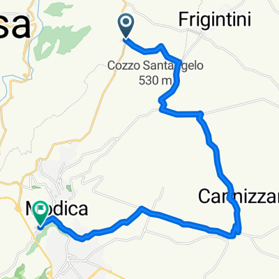
Overview
About this route
Frigintini countryside tiramisu AttivitàCiclismoDistanza47,5 kmCreato2020-02-21 10:55:51Velocità max40,9 km/hRitmo05:44 min/kmEnergia8592 KJPunti2129TuttoVelocità > 0Velocità media10,5 km/h15,2 km/hDurata traccia4 h:31 min:50 sec3 h:05 min:52 secAltitudine min69 mAltitudine max526 mElevazioneDistanzaIn salita677 m13302 mIn discesa-750 m15708 mIn piano0 m18461 m
- -:--
- Duration
- 41.1 km
- Distance
- 547 m
- Ascent
- 560 m
- Descent
- ---
- Avg. speed
- 528 m
- Max. altitude
Route quality
Waytypes & surfaces along the route
Waytypes
Road
32.8 km
(80 %)
Quiet road
7.2 km
(18 %)
Surfaces
Paved
32.9 km
(80 %)
Unpaved
1.1 km
(3 %)
Asphalt
32.6 km
(79 %)
Gravel
1.1 km
(3 %)
Continue with Bikemap
Use, edit, or download this cycling route
You would like to ride Frigintini countryside tiramisu bis2021 or customize it for your own trip? Here is what you can do with this Bikemap route:
Free features
- Save this route as favorite or in collections
- Copy & plan your own version of this route
- Sync your route with Garmin or Wahoo
Premium features
Free trial for 3 days, or one-time payment. More about Bikemap Premium.
- Navigate this route on iOS & Android
- Export a GPX / KML file of this route
- Create your custom printout (try it for free)
- Download this route for offline navigation
Discover more Premium features.
Get Bikemap PremiumFrom our community
Other popular routes starting in Campanella-Gianforma
 Giro a velocità lenta in
- Distance
- 5.3 km
- Ascent
- 89 m
- Descent
- 86 m
- Location
- Campanella-Gianforma, Sicily, Italy
 Da Contrada Cannizzara 9/a, Cannizzara a Contrada Cannizzara 9/a, Cannizzara
- Distance
- 70 km
- Ascent
- 923 m
- Descent
- 921 m
- Location
- Campanella-Gianforma, Sicily, Italy
 Noto -Palazzolo
- Distance
- 82.7 km
- Ascent
- 811 m
- Descent
- 810 m
- Location
- Campanella-Gianforma, Sicily, Italy
 Frigintini countryside tiramisu bis2021
- Distance
- 41.1 km
- Ascent
- 547 m
- Descent
- 560 m
- Location
- Campanella-Gianforma, Sicily, Italy
 Anello Castelluccio
- Distance
- 83.4 km
- Ascent
- 810 m
- Descent
- 810 m
- Location
- Campanella-Gianforma, Sicily, Italy
 Unnamed Road, Modica to Pozzallo, Zona Portuale
- Distance
- 37.6 km
- Ascent
- 291 m
- Descent
- 802 m
- Location
- Campanella-Gianforma, Sicily, Italy
 Strada Provinciale 107 14, Case Bibiola to Unnamed Road, Ragusa
- Distance
- 11.1 km
- Ascent
- 173 m
- Descent
- 332 m
- Location
- Campanella-Gianforma, Sicily, Italy
 variante cava d'ispica
- Distance
- 20.8 km
- Ascent
- 222 m
- Descent
- 431 m
- Location
- Campanella-Gianforma, Sicily, Italy
Open it in the app