

Tour zum Neusiedlersee
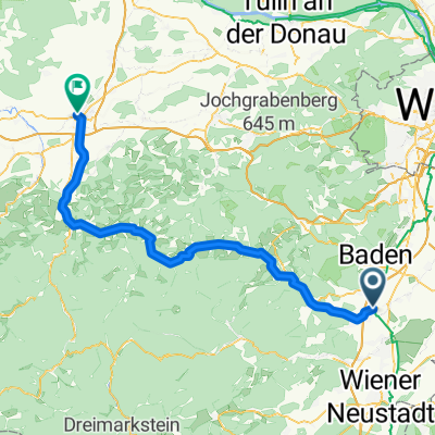
A cycling route starting in Leobersdorf, Lower Austria, Austria.
Overview
About this route
Hirtenberg - Rust and back over the Leithagebirge... mostly flat with 2 moderate climbs... always windy, but beautiful scenery... plenty of places to stock up with snacks of all kinds available!
- -:--
- Duration
- 113.1 km
- Distance
- 524 m
- Ascent
- 524 m
- Descent
- ---
- Avg. speed
- ---
- Max. altitude
Route quality
Waytypes & surfaces along the route
Waytypes
Quiet road
10.2 km
(9 %)
Road
5.7 km
(5 %)
Surfaces
Paved
69 km
(61 %)
Unpaved
1.1 km
(1 %)
Asphalt
67.9 km
(60 %)
Paved (undefined)
1.1 km
(1 %)
Continue with Bikemap
Use, edit, or download this cycling route
You would like to ride Tour zum Neusiedlersee or customize it for your own trip? Here is what you can do with this Bikemap route:
Free features
- Save this route as favorite or in collections
- Copy & plan your own version of this route
- Split it into stages to create a multi-day tour
- Sync your route with Garmin or Wahoo
Premium features
Free trial for 3 days, or one-time payment. More about Bikemap Premium.
- Navigate this route on iOS & Android
- Export a GPX / KML file of this route
- Create your custom printout (try it for free)
- Download this route for offline navigation
Discover more Premium features.
Get Bikemap PremiumFrom our community
Other popular routes starting in Leobersdorf
 Rund um die Hohe Wand
- Distance
- 77.1 km
- Ascent
- 1,098 m
- Descent
- 986 m
- Location
- Leobersdorf, Lower Austria, Austria
 Von Leobersdorf bis Hainfeld
- Distance
- 47.9 km
- Ascent
- 1,048 m
- Descent
- 881 m
- Location
- Leobersdorf, Lower Austria, Austria
 Bahnhofplatz, Leobersdorf to Kremser Gasse, St. Pölten
- Distance
- 82.3 km
- Ascent
- 1,113 m
- Descent
- 1,097 m
- Location
- Leobersdorf, Lower Austria, Austria
 Rund um Leobersdorf
- Distance
- 36.3 km
- Ascent
- 261 m
- Descent
- 262 m
- Location
- Leobersdorf, Lower Austria, Austria
 Von Leobersdorf bis Hainfeld
- Distance
- 46.4 km
- Ascent
- 1,041 m
- Descent
- 881 m
- Location
- Leobersdorf, Lower Austria, Austria
 Großauer Höhe
- Distance
- 26 km
- Ascent
- 239 m
- Descent
- 239 m
- Location
- Leobersdorf, Lower Austria, Austria
 Pfarrkogelstrecke 16km 160hm
- Distance
- 15.7 km
- Ascent
- 195 m
- Descent
- 194 m
- Location
- Leobersdorf, Lower Austria, Austria
 Thermenregio zur Rosalia 01
- Distance
- 76.7 km
- Ascent
- 817 m
- Descent
- 810 m
- Location
- Leobersdorf, Lower Austria, Austria
Open it in the app