

Let's drink it @ Jăratec Varianta de traseu 1
A cycling route starting in Pantelimon, Ilfov, Romania.
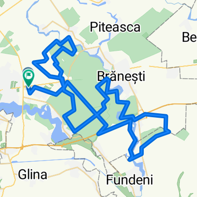
Overview
About this route
zona de la parcarea masinii pana la punctul de campare este mai abrupta si cu dificultate ceva mai ridicata.
- -:--
- Duration
- 14.6 km
- Distance
- 56 m
- Ascent
- 73 m
- Descent
- ---
- Avg. speed
- ---
- Max. altitude
Route quality
Waytypes & surfaces along the route
Waytypes
Quiet road
3.6 km
(25 %)
Access road
0.9 km
(6 %)
Surfaces
Paved
11.4 km
(78 %)
Unpaved
1.8 km
(12 %)
Asphalt
11.2 km
(77 %)
Ground
1.2 km
(8 %)
Route highlights
Points of interest along the route
Point of interest after 13.7 km
parcarea masinii.
Continue with Bikemap
Use, edit, or download this cycling route
You would like to ride Let's drink it @ Jăratec Varianta de traseu 1 or customize it for your own trip? Here is what you can do with this Bikemap route:
Free features
- Save this route as favorite or in collections
- Copy & plan your own version of this route
- Sync your route with Garmin or Wahoo
Premium features
Free trial for 3 days, or one-time payment. More about Bikemap Premium.
- Navigate this route on iOS & Android
- Export a GPX / KML file of this route
- Create your custom printout (try it for free)
- Download this route for offline navigation
Discover more Premium features.
Get Bikemap PremiumFrom our community
Other popular routes starting in Pantelimon
 Tura prin Cernica
- Distance
- 41 km
- Ascent
- 123 m
- Descent
- 128 m
- Location
- Pantelimon, Ilfov, Romania
 Bucuresti MTB Cernica Green 49 km (ADE 208) Bucuresti - Pd. Pustnicu - raul Pasarea - Pd. Cernica - Cernica - Bucuresti
- Distance
- 48.8 km
- Ascent
- 189 m
- Descent
- 192 m
- Location
- Pantelimon, Ilfov, Romania
 Ziua B - Traseul standard
- Distance
- 31.2 km
- Ascent
- 59 m
- Descent
- 60 m
- Location
- Pantelimon, Ilfov, Romania
 Bucuresti MTB Cernica Yellow 28 km (ADE 215) Bucuresti - Pd. Caldararu - L. Cernica - Pd. Cernica - Bucuresti
- Distance
- 27.7 km
- Ascent
- 102 m
- Descent
- 100 m
- Location
- Pantelimon, Ilfov, Romania
 Ziua B - Traseul Epic
- Distance
- 65.1 km
- Ascent
- 129 m
- Descent
- 132 m
- Location
- Pantelimon, Ilfov, Romania
 Bucuresti - Cernica - Vadu Anei - Branesti -Bucuresti
- Distance
- 44.2 km
- Ascent
- 74 m
- Descent
- 78 m
- Location
- Pantelimon, Ilfov, Romania
 Patelimon - Tătaru (2)
- Distance
- 139.6 km
- Ascent
- 108 m
- Descent
- 140 m
- Location
- Pantelimon, Ilfov, Romania
 Inconjur Lac Cernica
- Distance
- 26.5 km
- Ascent
- 75 m
- Descent
- 75 m
- Location
- Pantelimon, Ilfov, Romania
Open it in the app