

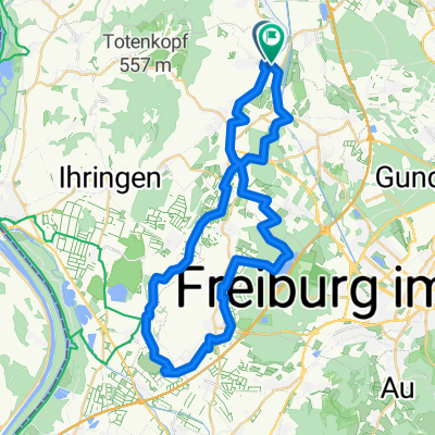
Von Eichstetten über die Schelingermatte, die Katharinenkappel und zurück.
A cycling route starting in Eichstetten, Baden-Wurttemberg, Germany.
Overview
About this route
Nice after-work ride for bikers. Technically not very demanding and also not a problem physically. Unless you ride fast...
- -:--
- Duration
- 17.4 km
- Distance
- 500 m
- Ascent
- 498 m
- Descent
- ---
- Avg. speed
- ---
- Max. altitude
Route highlights
Points of interest along the route
Point of interest after 17.3 km
Daheim
Continue with Bikemap
Use, edit, or download this cycling route
You would like to ride Von Eichstetten über die Schelingermatte, die Katharinenkappel und zurück. or customize it for your own trip? Here is what you can do with this Bikemap route:
Free features
- Save this route as favorite or in collections
- Copy & plan your own version of this route
- Sync your route with Garmin or Wahoo
Premium features
Free trial for 3 days, or one-time payment. More about Bikemap Premium.
- Navigate this route on iOS & Android
- Export a GPX / KML file of this route
- Create your custom printout (try it for free)
- Download this route for offline navigation
Discover more Premium features.
Get Bikemap PremiumFrom our community
Other popular routes starting in Eichstetten
 Um den Tuniberg
- Distance
- 45.3 km
- Ascent
- 187 m
- Descent
- 190 m
- Location
- Eichstetten, Baden-Wurttemberg, Germany
 Rund Kaiserstuhl
- Distance
- 59.2 km
- Ascent
- 84 m
- Descent
- 94 m
- Location
- Eichstetten, Baden-Wurttemberg, Germany
 GA1 nachmittagsrunde
- Distance
- 57.7 km
- Ascent
- 114 m
- Descent
- 118 m
- Location
- Eichstetten, Baden-Wurttemberg, Germany
 Teningen direction Freiburg
- Distance
- 81.5 km
- Ascent
- 851 m
- Descent
- 844 m
- Location
- Eichstetten, Baden-Wurttemberg, Germany
 Eichstetten Sexau Scheerhof zurück
- Distance
- 52.1 km
- Ascent
- 261 m
- Descent
- 265 m
- Location
- Eichstetten, Baden-Wurttemberg, Germany
 Eichstetten am Kaiserstuhl
- Distance
- 55.7 km
- Ascent
- 108 m
- Descent
- 103 m
- Location
- Eichstetten, Baden-Wurttemberg, Germany
 arbeitsweg
- Distance
- 7.5 km
- Ascent
- 8 m
- Descent
- 19 m
- Location
- Eichstetten, Baden-Wurttemberg, Germany
 Von Eichstetten über die Schelingermatte, die Katharinenkappel und zurück.
- Distance
- 17.4 km
- Ascent
- 500 m
- Descent
- 498 m
- Location
- Eichstetten, Baden-Wurttemberg, Germany
Open it in the app