
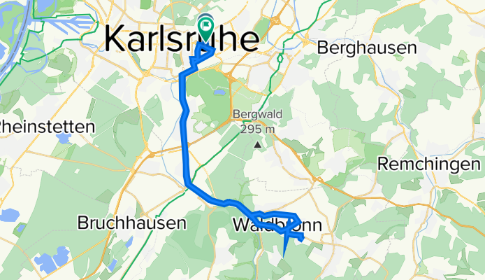
Lachnerstraße 11, Karlsruhe nach Sommerstraße 16, Karlsruhe
A cycling route starting in Karlsruhe, Baden-Wurttemberg, Germany.
Overview
About this route
- 2 h 10 min
- Duration
- 32.7 km
- Distance
- 669 m
- Ascent
- 555 m
- Descent
- 15.1 km/h
- Avg. speed
- ---
- Max. altitude
Continue with Bikemap
Use, edit, or download this cycling route
You would like to ride Lachnerstraße 11, Karlsruhe nach Sommerstraße 16, Karlsruhe or customize it for your own trip? Here is what you can do with this Bikemap route:
Free features
- Save this route as favorite or in collections
- Copy & plan your own version of this route
- Sync your route with Garmin or Wahoo
Premium features
Free trial for 3 days, or one-time payment. More about Bikemap Premium.
- Navigate this route on iOS & Android
- Export a GPX / KML file of this route
- Create your custom printout (try it for free)
- Download this route for offline navigation
Discover more Premium features.
Get Bikemap PremiumFrom our community
Other popular routes starting in Karlsruhe
 KA: Abendlicher Rundkurs +/- 1h 15min
- Distance
- 30.5 km
- Ascent
- 51 m
- Descent
- 49 m
- Location
- Karlsruhe, Baden-Wurttemberg, Germany
 Kreuzung Adenauerring / Grabener Allee zur Insel Rott
- Distance
- 16.5 km
- Ascent
- 17 m
- Descent
- 37 m
- Location
- Karlsruhe, Baden-Wurttemberg, Germany
 KA: Traingsrundentestfahrt
- Distance
- 34.7 km
- Ascent
- 49 m
- Descent
- 47 m
- Location
- Karlsruhe, Baden-Wurttemberg, Germany
 n bisschen Schwarzwald
- Distance
- 55.4 km
- Ascent
- 670 m
- Descent
- 656 m
- Location
- Karlsruhe, Baden-Wurttemberg, Germany
 durch die Vorderpfalz
- Distance
- 69.7 km
- Ascent
- 141 m
- Descent
- 150 m
- Location
- Karlsruhe, Baden-Wurttemberg, Germany
 KA -> Bad Herrenalb und über Bernbach zurück
- Distance
- 62.1 km
- Ascent
- 487 m
- Descent
- 487 m
- Location
- Karlsruhe, Baden-Wurttemberg, Germany
 KA - Durlach - Wattkopf - Muschelbach - Thomashof - KA
- Distance
- 48.9 km
- Ascent
- 656 m
- Descent
- 654 m
- Location
- Karlsruhe, Baden-Wurttemberg, Germany
 Karlsruhe - Turmberg - Stupferich - Mutschelbach - Langensteinbach - Ittersbach - Schöllbronn - Ettlingen - Karlsruhe
- Distance
- 59 km
- Ascent
- 514 m
- Descent
- 515 m
- Location
- Karlsruhe, Baden-Wurttemberg, Germany
Open it in the app