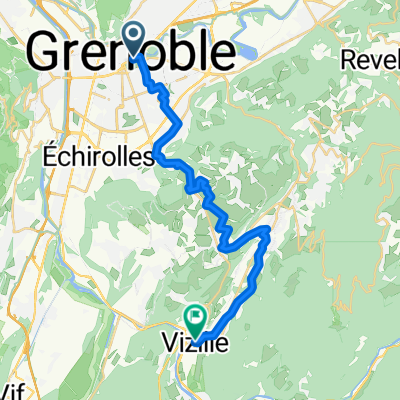
1ere etape Grenoble Villerest
A cycling route starting in La Tronche, Auvergne-Rh么ne-Alpes, France.
Overview
About this route
- -:--
- Duration
- 206.5 km
- Distance
- 1,354 m
- Ascent
- 1,204 m
- Descent
- ---
- Avg. speed
- ---
- Avg. speed
Route quality
Waytypes & surfaces along the route
Waytypes
Quiet road
61.6 km
(30 %)
Road
58 km
(28 %)
Surfaces
Paved
77.2 km
(37 %)
Unpaved
2.1 km
(<1 %)
Asphalt
77.1 km
(37 %)
Ground
2 km
(<1 %)
Continue with Bikemap
Use, edit, or download this cycling route
You would like to ride 1ere etape Grenoble Villerest or customize it for your own trip? Here is what you can do with this Bikemap route:
Free features
- Save this route as favorite or in collections
- Copy & plan your own version of this route
- Sync your route with Garmin or Wahoo
Premium features
Free trial for 3 days, or one-time payment. More about Bikemap Premium.
- Navigate this route on iOS & Android
- Export a GPX / KML file of this route
- Create your custom printout (try it for free)
- Download this route for offline navigation
Discover more Premium features.
Get Bikemap PremiumFrom our community
Other popular routes starting in La Tronche
- Grenoble - Valbonnais
- Distance
- 83.5 km
- Ascent
- 2,263 m
- Descent
- 1,629 m
- Location
- La Tronche, Auvergne-Rh么ne-Alpes, France
- Grenoble - La Terrasse - Dom猫ne - Uriage - Pont de Claix - Grenoble
- Distance
- 79.7 km
- Ascent
- 426 m
- Descent
- 426 m
- Location
- La Tronche, Auvergne-Rh么ne-Alpes, France
- Tronche-Col de Porte(classique)
- Distance
- 15 km
- Ascent
- 1,129 m
- Descent
- 30 m
- Location
- La Tronche, Auvergne-Rh么ne-Alpes, France
- Grenoble 1
- Distance
- 87.8 km
- Ascent
- 1,262 m
- Descent
- 1,259 m
- Location
- La Tronche, Auvergne-Rh么ne-Alpes, France
- Route nach Lans-en-Vercors
- Distance
- 28.1 km
- Ascent
- 1,249 m
- Descent
- 451 m
- Location
- La Tronche, Auvergne-Rh么ne-Alpes, France
- Grenoble - Voiron - Col de Porte
- Distance
- 84.3 km
- Ascent
- 2,159 m
- Descent
- 2,158 m
- Location
- La Tronche, Auvergne-Rh么ne-Alpes, France
- Alps June 5-9
- Distance
- 799.9 km
- Ascent
- 19,386 m
- Descent
- 19,422 m
- Location
- La Tronche, Auvergne-Rh么ne-Alpes, France
- Ride sympa
- Distance
- 46.9 km
- Ascent
- 312 m
- Descent
- 310 m
- Location
- La Tronche, Auvergne-Rh么ne-Alpes, France
Open it in the app