
My saved routes
A collection of 10 cycling routes, created by hribovc.
Overview
About this collection
This collection contains all routes that were previously saved.
- 10
- Routes
- -:--
- Duration
- 635.7 km
- Distance
- ---
- Avg. speed
- 7,040 m
- Ascent
- 6,440 m
- Descent
created this 9 years ago
My saved routes
Routes in this collection
All 10 routes in this collection can be opened on the map or in the Bikemap App for more details, where you can adjust them in the route planner, or download them as GPX or KML file. Use them as a template for planning your own rides, or let Bikemap navigate you along them directly.

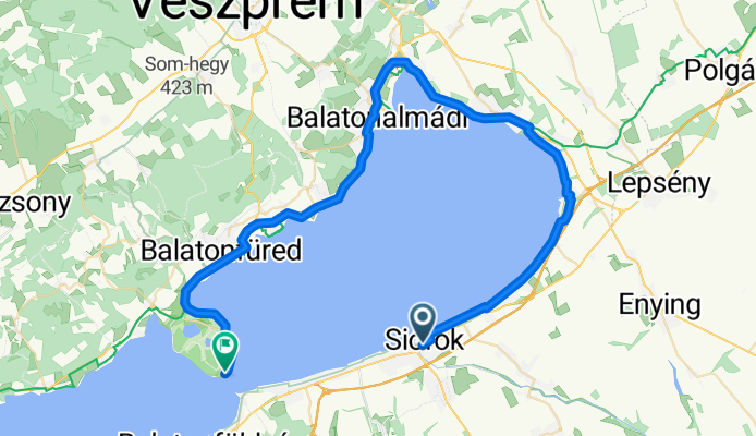
Balaton 3. Deň
Cycling route in Siófok, Somogy County, Hungary
- 60.2 km
- Distance
- 166 m
- Ascent
- 170 m
- Descent

Muljava-Rašica (via Dobeno)
Cycling route in Mengeš, Občina Mengeš, Slovenia
- 17.5 km
- Distance
- 438 m
- Ascent
- 445 m
- Descent


Mengeš-Vel.Lašna-Lukovica-Mengeš
Cycling route in Mengeš, Občina Mengeš, Slovenia
- 33.9 km
- Distance
- 533 m
- Ascent
- 533 m
- Descent


lucija-umag-novigrad-buje-lucija
Cycling route in Lucija, Piran, Slovenia
- 73.3 km
- Distance
- 476 m
- Ascent
- 475 m
- Descent


Na Konja
Cycling route in Kamnik, Kamnik, Slovenia
- 27.4 km
- Distance
- 1,151 m
- Ascent
- 197 m
- Descent
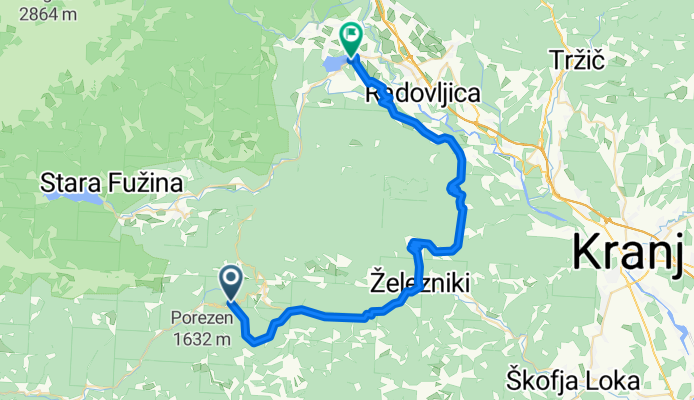
Bihinjske_sedlo_Bled
Cycling route in Bohinjska Bistrica, Bohinj Municipality, Slovenia
- 48.3 km
- Distance
- 706 m
- Ascent
- 1,034 m
- Descent