
My saved routes
A collection of 12 cycling routes, created by Reinhard.
Overview
About this collection
This collection contains all routes that were previously saved.
- 12
- Routes
- -:--
- Duration
- 1,838.8 km
- Distance
- ---
- Avg. speed
- 17,080 m
- Ascent
- 18,542 m
- Descent

created this 9 years ago
My saved routes
Routes in this collection
All 12 routes in this collection can be opened on the map or in the Bikemap App for more details, where you can adjust them in the route planner, or download them as GPX or KML file. Use them as a template for planning your own rides, or let Bikemap navigate you along them directly.

4. Etappe über Forcella Franche-Val del Mis
Cycling route in Falcade, Veneto, Italy
- 158.7 km
- Distance
- 902 m
- Ascent
- 2,082 m
- Descent

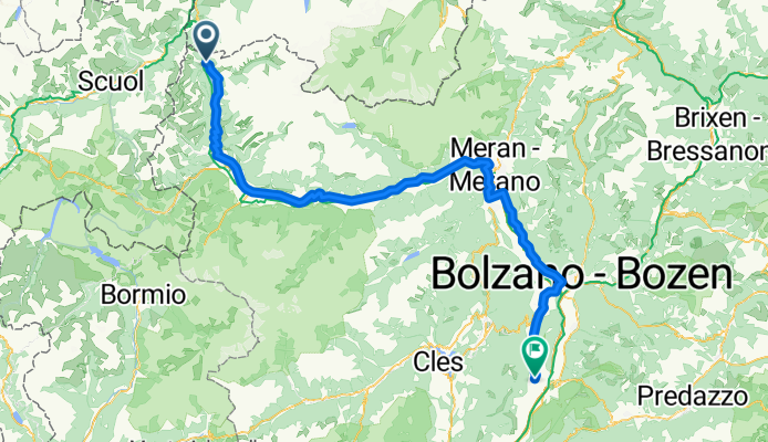
3a. Etappe Tramin-Falcade, Variante B
Cycling route in Termeno, Trentino-Alto Adige, Italy
- 73.4 km
- Distance
- 1,957 m
- Ascent
- 1,052 m
- Descent

3. Etappe Mittenwald - Venedig
Cycling route in Termeno, Trentino-Alto Adige, Italy
- 72.2 km
- Distance
- 2,010 m
- Ascent
- 1,131 m
- Descent
2. Etappe Garmisch- Venedig
Cycling route in Graun im Vinschgau, Trentino-Alto Adige, Italy
- 126.3 km
- Distance
- 389 m
- Ascent
- 1,656 m
- Descent

1. Etappe 15.6.15 Mittenwald - Reschen
Cycling route in Mittenwald, Bavaria, Germany
- 131 km
- Distance
- 1,988 m
- Ascent
- 1,394 m
- Descent

Cappuccino-Abschluß 2014
Cycling route in Göttingen, Lower Saxony, Germany
- 180.4 km
- Distance
- 783 m
- Ascent
- 774 m
- Descent

Cappuccino-Tour Bad Tölz - Venedig Etappe 2
Cycling route in Sterzing, Trentino-Alto Adige, Italy
- 109.7 km
- Distance
- 1,580 m
- Ascent
- 1,342 m
- Descent
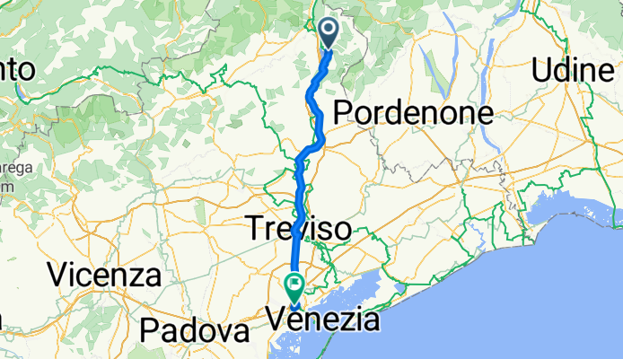
Cappuccino-Tour Bad Tölz - Venedig Etappe 4
Cycling route in Farra d'Alpago, Veneto, Italy
- 84.8 km
- Distance
- 121 m
- Ascent
- 510 m
- Descent

Cappuccino-Tour Bad Tölz - Venedig Etappe 3
Cycling route in Cortina d'Ampezzo, Veneto, Italy
- 96.7 km
- Distance
- 1,253 m
- Ascent
- 2,084 m
- Descent

Mehrtagesfahrt München - Venedig
Cycling route in Munich, Bavaria, Germany
- 473.4 km
- Distance
- 2,698 m
- Ascent
- 3,215 m
- Descent

Tagestour Leine-Werra-Unstrut-Leinetal 24.5.2014
Cycling route in Göttingen, Lower Saxony, Germany
- 160.6 km
- Distance
- 1,109 m
- Ascent
- 1,109 m
- Descent

Gö_Meißner_Friedland_Hoher Hagen_Gö
Cycling route in Rosdorf, Lower Saxony, Germany
- 171.4 km
- Distance
- 2,290 m
- Ascent
- 2,193 m
- Descent