
My saved routes
A collection of 13 cycling routes, created by cubes.
Overview
About this collection
This collection contains all routes that were previously saved.
- 13
- Routes
- -:--
- Duration
- 1,247.1 km
- Distance
- ---
- Avg. speed
- 11,330 m
- Ascent
- 10,823 m
- Descent
created this 9 years ago
My saved routes
Routes in this collection
All 13 routes in this collection can be opened on the map or in the Bikemap App for more details, where you can adjust them in the route planner, or download them as GPX or KML file. Use them as a template for planning your own rides, or let Bikemap navigate you along them directly.

2013-05-Freixo de Espade
Cycling route in Torregamones, Castille and León, Spain
- 90.7 km
- Distance
- 827 m
- Ascent
- 987 m
- Descent

Caminho Portugueis 1.Etappe
Cycling route in Lisbon, Lisbon District, Portugal
- 91.7 km
- Distance
- 254 m
- Ascent
- 184 m
- Descent

Genf - Lissabon
Cycling route in Pleaux, Auvergne-Rhône-Alpes, France
- 229.3 km
- Distance
- 2,194 m
- Ascent
- 2,227 m
- Descent

Fumel - Pau
Cycling route in Fumel, Nouvelle-Aquitaine, France
- 202.8 km
- Distance
- 959 m
- Ascent
- 826 m
- Descent

Cahors-Fumel 57 km
Cycling route in Cahors, Occitanie, France
- 57 km
- Distance
- 384 m
- Ascent
- 430 m
- Descent
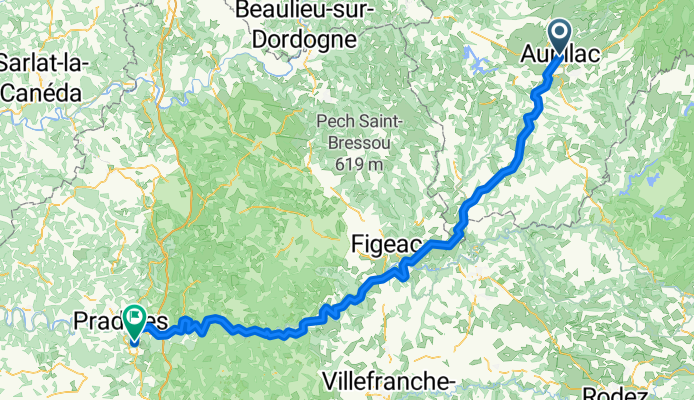
Aurillac - Cahors
Cycling route in Aurillac, Auvergne-Rhône-Alpes, France
- 144.4 km
- Distance
- 587 m
- Ascent
- 1,086 m
- Descent

Clermont-Ferrand - Aurillac
Cycling route in Clermont-Ferrand, Auvergne-Rhône-Alpes, France
- 149.2 km
- Distance
- 2,224 m
- Ascent
- 1,943 m
- Descent

Roanne - Clermont-Ferrand
Cycling route in Roanne, Auvergne-Rhône-Alpes, France
- 103.1 km
- Distance
- 1,185 m
- Ascent
- 1,110 m
- Descent

St. Just - Thiers - Clermont-Ferrand Teil2
Cycling route in Thiers, Auvergne-Rhône-Alpes, France
- 42.6 km
- Distance
- 293 m
- Ascent
- 273 m
- Descent

Clermont - Besse St Anaesteise Teil 1
Cycling route in Royat, Auvergne-Rhône-Alpes, France
- 6.8 km
- Distance
- 443 m
- Ascent
- 47 m
- Descent

Villefranche-St Just de Chevalier Teil 1
Cycling route in Villefranche-sur-Saône, Auvergne-Rhône-Alpes, France
- 70.6 km
- Distance
- 900 m
- Ascent
- 734 m
- Descent

Villefranche-St Just de Chevalet Teil 2
Cycling route in Balbigny, Auvergne-Rhône-Alpes, France
- 30.3 km
- Distance
- 460 m
- Ascent
- 148 m
- Descent