
My saved routes
A collection of 12 cycling routes, created by TheMortal.
Overview
About this collection
This collection contains all routes that were previously saved.
- 12
- Routes
- -:--
- Duration
- 421.5 km
- Distance
- ---
- Avg. speed
- 9,505 m
- Ascent
- 9,068 m
- Descent

created this 9 years ago
My saved routes
Routes in this collection
All 12 routes in this collection can be opened on the map or in the Bikemap App for more details, where you can adjust them in the route planner, or download them as GPX or KML file. Use them as a template for planning your own rides, or let Bikemap navigate you along them directly.

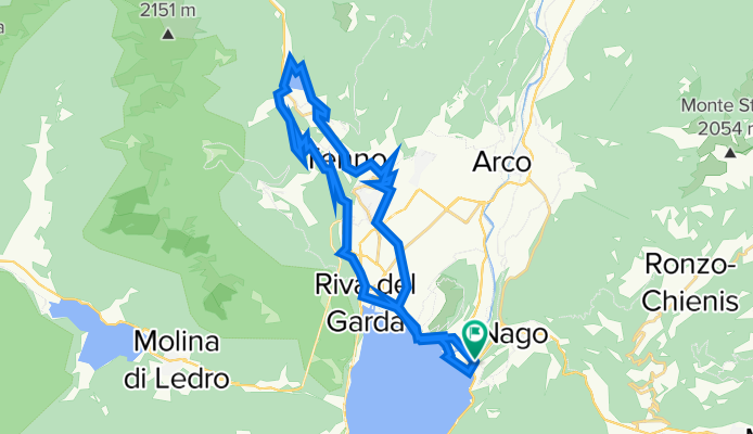
Riva del Garda-Lago di Tenno-Arco-Torbole
Cycling route in Torbole sul Garda, Trentino-Alto Adige, Italy
- 41.3 km
- Distance
- 741 m
- Ascent
- 726 m
- Descent
Torbole-Tennosee
Cycling route in Torbole sul Garda, Trentino-Alto Adige, Italy
- 30.1 km
- Distance
- 577 m
- Ascent
- 576 m
- Descent
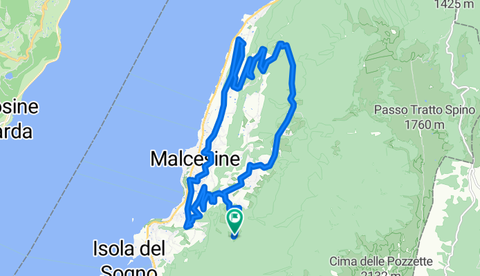
San Maggiore - Malcesine
Cycling route in Malcesine, Veneto, Italy
- 16.7 km
- Distance
- 734 m
- Ascent
- 734 m
- Descent

Tignale Sky biking
Cycling route in Gardola, Lombardy, Italy
- 25.8 km
- Distance
- 902 m
- Ascent
- 911 m
- Descent

MB Tour Sosso dei Roveri 2
Cycling route in Torbole sul Garda, Trentino-Alto Adige, Italy
- 33.9 km
- Distance
- 1,348 m
- Ascent
- 1,351 m
- Descent

Torbole - Capanna Grassi
Cycling route in Torbole sul Garda, Trentino-Alto Adige, Italy
- 31.1 km
- Distance
- 1,275 m
- Ascent
- 849 m
- Descent

Haibike AMT RX 2014 Testrunde
Cycling route in Costermano, Veneto, Italy
- 39.3 km
- Distance
- 597 m
- Ascent
- 592 m
- Descent


Gardasee Oktober 2015
Cycling route in Colà, Veneto, Italy
- 55.7 km
- Distance
- 305 m
- Ascent
- 306 m
- Descent

Pętelka wokół Ślęży czarnym szlakiem
Cycling route in Sobótka, Lower Silesian Voivodeship, Poland
- 17.9 km
- Distance
- 387 m
- Ascent
- 387 m
- Descent

Suvretta-Pass
Cycling route in Celerina, Grisons, Switzerland
- 34.4 km
- Distance
- 1,118 m
- Ascent
- 1,115 m
- Descent

Michałkowa - Wielka Sowa, mój klasyk
Cycling route in Dziećmorowice, Lower Silesian Voivodeship, Poland
- 31.7 km
- Distance
- 753 m
- Ascent
- 753 m
- Descent