Via Claudia
A collection of 13 cycling routes, created by Frank Wolf.
Overview
About this collection
Tag 2
- 13
- Routes
- 15 h 37 min
- Duration
- 1,239.8 km
- Distance
- 79.4 km/h
- Avg. speed
- 12,416 m
- Ascent
- 16,117 m
- Descent
Frank Wolf
created this 5 years ago
Via Claudia
Routes in this collection
All 13 routes in this collection can be opened on the map or in the Bikemap App for more details, where you can adjust them in the route planner, or download them as GPX or KML file. Use them as a template for planning your own rides, or let Bikemap navigate you along them directly.

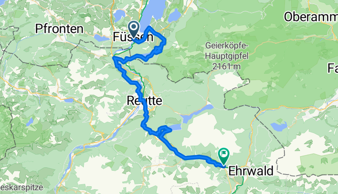
2 Tag Imst- Nauders Via Claudia
Cycling route in Imst, Tyrol, Austria
- 71.5 km
- Distance
- 888 m
- Ascent
- 300 m
- Descent

Via Claudia Augusta
Cycling route in Füssen, Bavaria, Germany
- 350.2 km
- Distance
- 1,368 m
- Ascent
- 2,099 m
- Descent


Lana über Lampen nach Riva del Garda
Cycling route in Lana, Trentino-Alto Adige, Italy
0 Lana
30 Fondo
48 Cles
80 Movelno
100 Sarche
122 Riva del Garda
- 122.2 km
- Distance
- 2,090 m
- Ascent
- 2,314 m
- Descent

Lana - Gampenpass - Cles 10.09.2016
Cycling route in Lana, Trentino-Alto Adige, Italy
- 58.7 km
- Distance
- 1,443 m
- Ascent
- 1,056 m
- Descent

5. Etappe AlpX Lana-Cles .gpx
Cycling route in Tscherms, Trentino-Alto Adige, Italy
TEASI track
- 55 km
- Distance
- 1,506 m
- Ascent
- 1,146 m
- Descent


AlpenX 5 Cles Riva
Cycling route in Cles, Trentino-Alto Adige, Italy
Etappe 5
- 85.4 km
- Distance
- 908 m
- Ascent
- 1,498 m
- Descent

4. Etappe AlpX Nauders-Meran-Lana.gpx
Cycling route in Nauders, Tyrol, Austria
TEASI track
- 93.6 km
- Distance
- 227 m
- Ascent
- 1,290 m
- Descent