
My saved routes
A collection of 31 cycling routes, created by Thomas Zeitler.
Overview
About this collection
This collection contains all routes that were previously saved.
- 31
- Routes
- -:--
- Duration
- 3,012.2 km
- Distance
- ---
- Avg. speed
- 43,063 m
- Ascent
- 42,975 m
- Descent

created this 9 years ago
My saved routes
Routes in this collection
All 31 routes in this collection can be opened on the map or in the Bikemap App for more details, where you can adjust them in the route planner, or download them as GPX or KML file. Use them as a template for planning your own rides, or let Bikemap navigate you along them directly.

Neusath - Zinzendorf
Cycling route in Nabburg, Bavaria, Germany
- 80.1 km
- Distance
- 707 m
- Ascent
- 802 m
- Descent

schnelle Trainingsrunde mit 700 HM
Cycling route in Pentling, Bavaria, Germany
- 60.9 km
- Distance
- 880 m
- Ascent
- 848 m
- Descent

carte 61c
Cycling route in Sarlat-la-Canéda, Nouvelle-Aquitaine, France
- 65.5 km
- Distance
- 639 m
- Ascent
- 639 m
- Descent

CIRCUIT N°3 BIS MARAVAL BERBIGUIERE SIORAC MEYRAL SARLAT
Cycling route in Sarlat-la-Canéda, Nouvelle-Aquitaine, France
- 76.8 km
- Distance
- 821 m
- Ascent
- 814 m
- Descent

carte 77
Cycling route in Sarlat-la-Canéda, Nouvelle-Aquitaine, France
- 84.3 km
- Distance
- 711 m
- Ascent
- 711 m
- Descent

CIRCUIT 116C
Cycling route in Sarlat-la-Canéda, Nouvelle-Aquitaine, France
- 89.4 km
- Distance
- 657 m
- Ascent
- 644 m
- Descent

CIRCUIT LA MENARDIE N°1
Cycling route in Sarlat-la-Canéda, Nouvelle-Aquitaine, France
- 85.4 km
- Distance
- 605 m
- Ascent
- 622 m
- Descent

Ausgedehnte Feierabendtour
Cycling route in Regensburg, Bavaria, Germany
- 62.9 km
- Distance
- 392 m
- Ascent
- 392 m
- Descent

Mittagsrunde Continental
Cycling route in Tegernheim, Bavaria, Germany
- 31 km
- Distance
- 22 m
- Ascent
- 25 m
- Descent
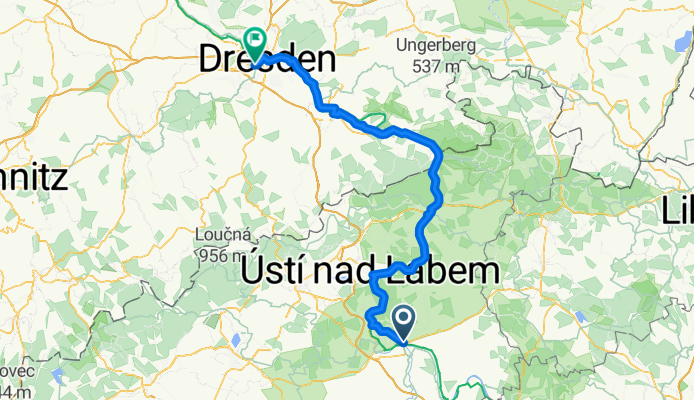
Elbabwärts letzte Etappe
Cycling route in Litoměřice, Ústecký kraj, Czechia
- 124.1 km
- Distance
- 539 m
- Ascent
- 578 m
- Descent

Regensburg Burgweinting (start) über Köferring, Mintraching und über die Dörfer an der Donau
Cycling route in Obertraubling, Bavaria, Germany
- 53.5 km
- Distance
- 51 m
- Ascent
- 52 m
- Descent

Stilfzer, Gavia,Timmelsjoch
Cycling route in Garmisch-Partenkirchen, Bavaria, Germany
- 663 km
- Distance
- 8,758 m
- Ascent
- 8,564 m
- Descent