
München-Tirol-Dolomittene-Trentino 2023
A collection of 9 cycling routes, created by Helge Guthormsen.
Overview
About this collection
Sommerferie Camilla og Helge. Aktiv ferie med mange høydepunkter.
- 9
- Routes
- 3 h 56 min
- Duration
- 548.1 km
- Distance
- 139.6 km/h
- Avg. speed
- 7,779 m
- Ascent
- 8,139 m
- Descent

created this 3 years ago
München-Tirol-Dolomittene-Trentino 2023
Routes in this collection
All 9 routes in this collection can be opened on the map or in the Bikemap App for more details, where you can adjust them in the route planner, or download them as GPX or KML file. Use them as a template for planning your own rides, or let Bikemap navigate you along them directly.
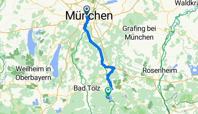
Munchen - Tegernsee 27.6.
Cycling route in Munich, Bavaria, Germany
- 66.8 km
- Distance
- 713 m
- Ascent
- 508 m
- Descent


22.6. Tegernsee - Maurach
Cycling route in Tegernsee, Bavaria, Germany
- 52.2 km
- Distance
- 1,170 m
- Ascent
- 972 m
- Descent

Maurach - Innsbruck 29. - 30.6.
Cycling route in Jenbach, Tyrol, Austria
- 48.3 km
- Distance
- 174 m
- Ascent
- 554 m
- Descent

Innsbruck - Mühlbach 1.7.
Cycling route in Innsbruck, Tyrol, Austria
- 92.7 km
- Distance
- 1,912 m
- Ascent
- 1,724 m
- Descent

Mühlbach - Toblach 2.7.
Cycling route in Mühlbach, Trentino-Alto Adige, Italy
- 56 km
- Distance
- 1,114 m
- Ascent
- 660 m
- Descent

Toblach - Cortina 3.7.
Cycling route in Toblach, Trentino-Alto Adige, Italy
- 30.2 km
- Distance
- 421 m
- Ascent
- 423 m
- Descent

Cortina - Pieve di Cadore 4.7.
Cycling route in Cortina d'Ampezzo, Veneto, Italy
- 32.7 km
- Distance
- 376 m
- Ascent
- 698 m
- Descent

Pieve di Cadore - Tezze 5.7.
Cycling route in Pieve di Cadore, Veneto, Italy
- 106.2 km
- Distance
- 1,361 m
- Ascent
- 2,022 m
- Descent

Tezze - Trento 6.7.
Cycling route in Grigno, Trentino-Alto Adige, Italy
- 62.9 km
- Distance
- 538 m
- Ascent
- 578 m
- Descent