
Cycling in Camiling
Discover a map of 8 cycling routes and bike trails near Camiling, created by our community.
Be a pioneer
Inspire fellow cyclists with your route in Camiling
Bikemap is a global cycling community with millions of routes created by cyclists like you. There are only a few routes so far in Camiling, so plot your favourite rides on the map now to help others find the best ways to ride.
From our community
The best bike routes in and around Camiling

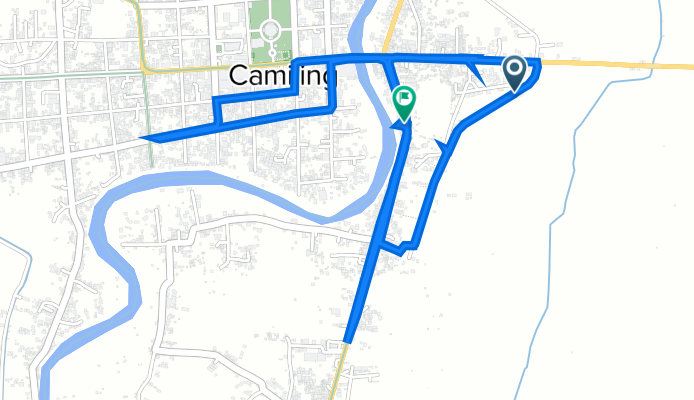
Romulo Highway 33, Camiling to MCM9+WGR, Camiling
Cycling route in Camiling, Central Luzon, Philippines
- 7 km
- Distance
- 210 m
- Ascent
- 210 m
- Descent

Romulo Highway 147, Camiling to Capas
Cycling route in Camiling, Central Luzon, Philippines
- 60.9 km
- Distance
- 476 m
- Ascent
- 369 m
- Descent
Paniqui - Camiling Road 463 to MCM9+WGR, Camiling
Cycling route in Camiling, Central Luzon, Philippines
- 8.7 km
- Distance
- 201 m
- Ascent
- 199 m
- Descent

Quezon Avenue 32, Camiling to MCH2+74G, Camiling
Cycling route in Camiling, Central Luzon, Philippines
- 10.9 km
- Distance
- 181 m
- Ascent
- 188 m
- Descent
Discover more routes
 M9PX+FXJ, Camiling to Romulo Highway 35, Camiling
- Distance
- 9.9 km
- Ascent
- 69 m
- Descent
- 42 m
- Location
- Camiling, Central Luzon, Philippines
 Unnamed Road, Camiling to Romulo Highway 10, Tarlac City
- Distance
- 48.8 km
- Ascent
- 280 m
- Descent
- 260 m
- Location
- Camiling, Central Luzon, Philippines
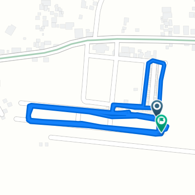
 pagpapanggap na takbuhan sa hapon
- Distance
- 5.4 km
- Ascent
- 26 m
- Descent
- 25 m
- Location
- Camiling, Central Luzon, Philippines
 mabilisang pagpapanggap
- Distance
- 2.7 km
- Ascent
- 13 m
- Descent
- 12 m
- Location
- Camiling, Central Luzon, Philippines