
Cycling in Höchst im Odenwald
Discover a map of 750 cycling routes and bike trails near Höchst im Odenwald, created by our community.
Region portrait
Get to know Höchst im Odenwald
Find the right bike route for you through Höchst im Odenwald, where we've got 750 cycle routes to explore. Most people get on their bikes to ride here in the months of July and August.
33,294 km
Tracked distance
750
Cycle routes
10,010
Population
Community
Most active users in Höchst im Odenwald


From our community
The best bike routes in and around Höchst im Odenwald


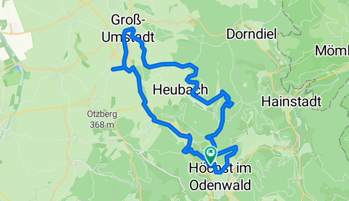
3 Brunnen Runde
Cycling route in Höchst im Odenwald, Hesse, Germany
- 31.2 km
- Distance
- 441 m
- Ascent
- 437 m
- Descent


über die Hohe Straße
Cycling route in Höchst im Odenwald, Hesse, Germany
- 25.3 km
- Distance
- 377 m
- Ascent
- 373 m
- Descent


Wald-Amorbach Runde
Cycling route in Höchst im Odenwald, Hesse, Germany
- 21.8 km
- Distance
- 579 m
- Ascent
- 580 m
- Descent


zum Biergarten nach Umscht
Cycling route in Höchst im Odenwald, Hesse, Germany
- 30.8 km
- Distance
- 470 m
- Ascent
- 465 m
- Descent
Discover more routes
 Frankfurter Straße-Binselberg-Wendelinuskapelle-Umstadt
- Distance
- 35.7 km
- Ascent
- 479 m
- Descent
- 477 m
- Location
- Höchst im Odenwald, Hesse, Germany
 Rimhorn-Lützelbach-Hainstadt Runde
- Distance
- 30.4 km
- Ascent
- 617 m
- Descent
- 620 m
- Location
- Höchst im Odenwald, Hesse, Germany
 zum Obernburger Waldhaus
- Distance
- 35.6 km
- Ascent
- 327 m
- Descent
- 324 m
- Location
- Höchst im Odenwald, Hesse, Germany
 Zur Konfirmanden Buche und in den Kellergrund
- Distance
- 25.4 km
- Ascent
- 789 m
- Descent
- 785 m
- Location
- Höchst im Odenwald, Hesse, Germany
 Zum Brauereihoffest Ederbräu
- Distance
- 39 km
- Ascent
- 480 m
- Descent
- 479 m
- Location
- Höchst im Odenwald, Hesse, Germany
 zum Schloß Fürstenau
- Distance
- 34.7 km
- Ascent
- 246 m
- Descent
- 244 m
- Location
- Höchst im Odenwald, Hesse, Germany
 von Brunnen zu Brunnen nach Erbach
- Distance
- 43.2 km
- Ascent
- 201 m
- Descent
- 199 m
- Location
- Höchst im Odenwald, Hesse, Germany
 Lengfeld und der Otzberg
- Distance
- 25.5 km
- Ascent
- 358 m
- Descent
- 376 m
- Location
- Höchst im Odenwald, Hesse, Germany