
Cycling in Sant Joan de Mollet
Discover a map of 21 cycling routes and bike trails near Sant Joan de Mollet, created by our community.
Region portrait
Get to know Sant Joan de Mollet
Find the right bike route for you through Sant Joan de Mollet, where we've got 21 cycle routes to explore.
1,025 km
Tracked distance
21
Cycle routes
Community
Most active users in Sant Joan de Mollet


From our community
The best bike routes in and around Sant Joan de Mollet

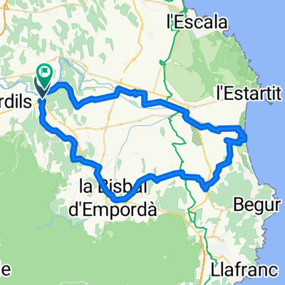
40 km Flaca - FLaca
Cycling route in Sant Joan de Mollet, Catalonia, Spain
40 km
- 38.7 km
- Distance
- 324 m
- Ascent
- 325 m
- Descent

Flaça-Estartit-Flaça
Cycling route in Sant Joan de Mollet, Catalonia, Spain
Some mistakes to be smoothed out in post. A couple of gravel roads make this harder than it seems.
- 62.9 km
- Distance
- 459 m
- Ascent
- 458 m
- Descent

4 day cycle
Cycling route in Sant Joan de Mollet, Catalonia, Spain
Divided in the following days
Flaca - Peratallada (visiting medival villages) 35 km some options are:
Can be made 10km longer by going from Pubol to Foixa, Rupia and then onto Corça.
Can also be reduced by 10km by going directly to Peratallada from Vulpellac (skipping Ullastret and Palau-sator).
Could add a trip to Pals and back (around 10km round trip)
Peratallada - Castello d'Empuries (along the coast - some rough tracks) 55km/90 total. St Marti d'Empuries is a good spot for lunch.
The first strech directly north from Peratallada gives you an idea of what awaits between L'Estartit and L'Escala. Alternativly go via Bellcaire d'Emporda to Albons.
Some alternative routes through the natural park of Aiguamolls are available to avoid the main road between St. Pere Pescador and Castello d'Empuries
Castello d'Empuries - Cadaques (visiting Cap de Creus lighthouse in the national park) 45 km/135 total
The first part to Palau-Saverdera is via a little used road but the rest of trip to Cadaques can be quite busy.
The climb to Cadaques is 3-4 km long (eases off at km 7 of the GI-614)
Suggested timing is to have lunch in Cadaques and use the afternoon for the trip to the lighthouse.
Cadaques - Figueres 45 km/180 total
Climb from Cadaques can be challenging but the road to Port de la Selva is a long relaxing descent
Rather than go into Llanca and onto Vilajuiga an alternative is to take the road up to St Pere de Rodes (avoids the busy N-260 but is a steep 400m/5km climb). Both options are around 14km from Port de la Selva to the N-260/C-252 intersection.
Peralada makes a good late lunch stop or from Garriguella we can add about 12 km by heading first to Vilamaniscle and Rabos before reaching Peralada and onto Figueres via the backroads.
- 180.1 km
- Distance
- 1,002 m
- Ascent
- 1,007 m
- Descent

57 km Flaca - L'Escala - Flaca
Cycling route in Sant Joan de Mollet, Catalonia, Spain
- 56.5 km
- Distance
- 261 m
- Ascent
- 263 m
- Descent
Discover more routes
 40 km Flaca - La Bisbal - Flaca
- Distance
- 38.6 km
- Ascent
- 323 m
- Descent
- 325 m
- Location
- Sant Joan de Mollet, Catalonia, Spain
 ASB Dads Tour de Mountains
- Distance
- 72.7 km
- Ascent
- 404 m
- Descent
- 404 m
- Location
- Sant Joan de Mollet, Catalonia, Spain
 Pobles Medievals de l'Empurdà
- Distance
- 86.9 km
- Ascent
- 371 m
- Descent
- 368 m
- Location
- Sant Joan de Mollet, Catalonia, Spain
 Flaca-Flaca
- Distance
- 62.6 km
- Ascent
- 261 m
- Descent
- 268 m
- Location
- Sant Joan de Mollet, Catalonia, Spain
 Flaca-Bisbal
- Distance
- 14.8 km
- Ascent
- 154 m
- Descent
- 152 m
- Location
- Sant Joan de Mollet, Catalonia, Spain
 Ruta a Plaça Poble 9, Bordils
- Distance
- 9.3 km
- Ascent
- 132 m
- Descent
- 161 m
- Location
- Sant Joan de Mollet, Catalonia, Spain
 tram flaçà girona
- Distance
- 24.5 km
- Ascent
- 108 m
- Descent
- 62 m
- Location
- Sant Joan de Mollet, Catalonia, Spain
 flaca aquarius
- Distance
- 77.4 km
- Ascent
- 261 m
- Descent
- 297 m
- Location
- Sant Joan de Mollet, Catalonia, Spain