
Cycling in Lindsborg
Discover a map of 9 cycling routes and bike trails near Lindsborg, created by our community.
Be a pioneer
Inspire fellow cyclists with your route in Lindsborg
Bikemap is a global cycling community with millions of routes created by cyclists like you. There are only a few routes so far in Lindsborg, so plot your favourite rides on the map now to help others find the best ways to ride.
From our community
The best bike routes in and around Lindsborg


Lindsborg via the Meadowlark Trail to Marquette
Cycling route in Lindsborg, Kansas, United States
- 49 km
- Distance
- 86 m
- Ascent
- 89 m
- Descent


Lindsborg to Coronado Heights
Cycling route in Lindsborg, Kansas, United States
- 14.7 km
- Distance
- 106 m
- Ascent
- 106 m
- Descent


Välkommen Trail - Lindsborg
Cycling route in Lindsborg, Kansas, United States
- 5 km
- Distance
- 11 m
- Ascent
- 9 m
- Descent


Falun Classic - Lindsborg to Falun Loop
Cycling route in Lindsborg, Kansas, United States
- 49.1 km
- Distance
- 135 m
- Ascent
- 133 m
- Descent
Discover more routes
 Lindsborg to Maxwell Wildlife Refuge
- Distance
- 70.8 km
- Ascent
- 298 m
- Descent
- 300 m
- Location
- Lindsborg, Kansas, United States
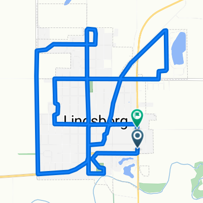 South Cole Street to South Cole Street
- Distance
- 16 km
- Ascent
- 81 m
- Descent
- 56 m
- Location
- Lindsborg, Kansas, United States
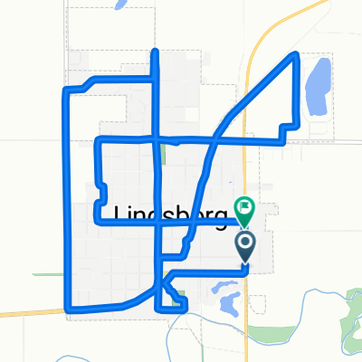 Cole1
Cole1- Distance
- 16.1 km
- Ascent
- 83 m
- Descent
- 62 m
- Location
- Lindsborg, Kansas, United States
 Lindsborg/Roxbury/Gypsum Loop
- Distance
- 76.2 km
- Ascent
- 198 m
- Descent
- 200 m
- Location
- Lindsborg, Kansas, United States
 708 Emerald Dr, Lindsborg to Bethany Dr, Lindsborg
- Distance
- 22.6 km
- Ascent
- 154 m
- Descent
- 152 m
- Location
- Lindsborg, Kansas, United States