
Cycling in Taylorsville
Discover a cycling-focused map of Taylorsville, featuring highlighted cycle paths, trails, and points of interest.
Be a pioneer
Inspire fellow cyclists with your route in Taylorsville
Bikemap is a global cycling community with millions of routes created by cyclists like you. There are only a few routes so far in Taylorsville, so plot your favourite rides on the map now to help others find the best ways to ride.
From our community
The best bike routes in and around Taylorsville


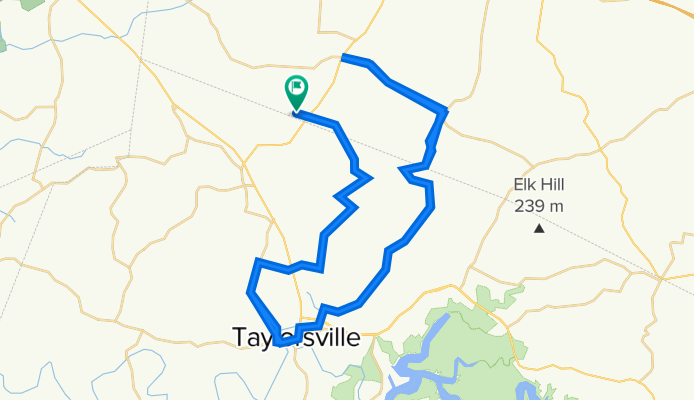
Chesapeake Meadows to Taylorsville DQ
Cycling route in Taylorsville, Kentucky, United States
This is just a fantastic route that begins in a cul-de-sac of Chesapeake Meadows Ct (very easy to park your vehicle) and goes through various picturesque settings including creeks, vistas, forested areas and more. There are several great side-jaunts along the way that you can take to add additional distance. Extremely low vehicular traffic for the vast majority of the route - and really no dangerous roads at all (except for 100 yds on 55 at the beginning / ending of the ride). We traditionally stop in at DQ for a mid-ride refresher. Just a great little route for a 2 1/2 - 4 hour excursion (depending on your speed and how long you linger at DQ :) )
- 40.1 km
- Distance
- 326 m
- Ascent
- 326 m
- Descent
Home-Finchville-Home 50 miles
Cycling route in Taylorsville, Kentucky, United States
- 82.8 km
- Distance
- 1,099 m
- Ascent
- 1,096 m
- Descent