
Cycling in Smokey Point
Discover a map of 19 cycling routes and bike trails near Smokey Point, created by our community.
Region portrait
Get to know Smokey Point
Find the right bike route for you through Smokey Point, where we've got 19 cycle routes to explore. Most people get on their bikes to ride here in the month of May.
569 km
Tracked distance
19
Cycle routes
1,572
Population
Community
Most active users in Smokey Point


From our community
The best bike routes in and around Smokey Point


Arlington to Seattle
Cycling route in Smokey Point, Washington, United States
- 97.6 km
- Distance
- 1,514 m
- Ascent
- 1,459 m
- Descent

Easy ride in Arlington
Cycling route in Smokey Point, Washington, United States
- 40.9 km
- Distance
- 196 m
- Ascent
- 195 m
- Descent
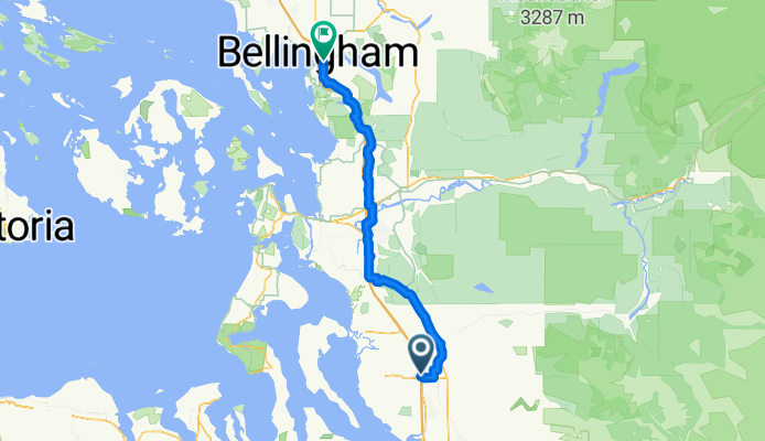
172nd St NE, Arlington to Lakeway Dr, Bellingham
Cycling route in Smokey Point, Washington, United States
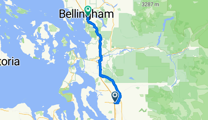
- 93.7 km
- Distance
- 604 m
- Ascent
- 593 m
- Descent
Smokey Point Dr, Arlington to Lakeway Dr, Bellingham
Cycling route in Smokey Point, Washington, United States
- 92.3 km
- Distance
- 964 m
- Ascent
- 952 m
- Descent
Discover more routes
 15405 67th Ave NE, Arlington to 15405 67th Ave NE, Arlington
- Distance
- 10.9 km
- Ascent
- 69 m
- Descent
- 70 m
- Location
- Smokey Point, Washington, United States
 15405 67th Ave NE, Arlington to 15405 67th Ave NE, Arlington
- Distance
- 11.1 km
- Ascent
- 74 m
- Descent
- 72 m
- Location
- Smokey Point, Washington, United States
 18828 Smokey Point Blvd, Arlington to 14714–14798 Summers Dr, Mount Vernon
- Distance
- 42.1 km
- Ascent
- 330 m
- Descent
- 348 m
- Location
- Smokey Point, Washington, United States
 15291–15359 67th Ave NE, Arlington to 15405 67th Ave NE, Arlington
- Distance
- 5.2 km
- Ascent
- 23 m
- Descent
- 23 m
- Location
- Smokey Point, Washington, United States
 15405 67th Ave NE, Arlington to 15405 67th Ave NE, Arlington
- Distance
- 11.1 km
- Ascent
- 65 m
- Descent
- 66 m
- Location
- Smokey Point, Washington, United States
 15405 67th Ave NE, Arlington to 15405 67th Ave NE, Arlington
- Distance
- 13 km
- Ascent
- 118 m
- Descent
- 116 m
- Location
- Smokey Point, Washington, United States
 15405 67th Ave NE, Arlington to 15405 67th Ave NE, Arlington
- Distance
- 11.1 km
- Ascent
- 86 m
- Descent
- 87 m
- Location
- Smokey Point, Washington, United States
 hdjdj
hdjdj- Distance
- 29.1 km
- Ascent
- 653 m
- Descent
- 634 m
- Location
- Smokey Point, Washington, United States