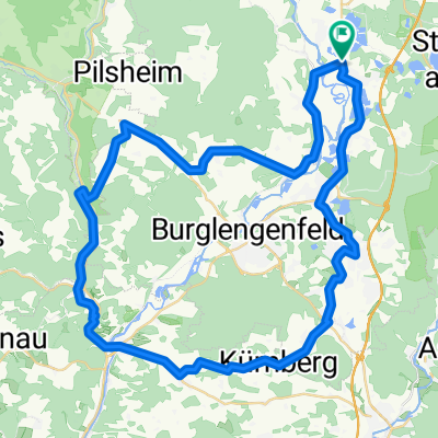
Kallmünz übers Vilstal
A cycling route starting in Schwandorf in Bayern, Bavaria, Germany.
Overview
About this route
Anfangs- und Endpunkt ist der Klardorfer Kreisel.
Die Route verläuft anfangs am westlichen Hang des Naabtales und erklimmt bei Premberg die Ausläufer des Oberpfälzer Jura. Ab Pettenhof bis Kallmünz folgt die Route dem Fünf-Flüsse-Radweg.
Die Route kann auch im Uhrzeigersinn befahren werden, dann ist allerdings zwischen der St 2165 und Lanzenried auf 800 m Länge eine 10%ige Steigung zu überwinden.
Die Route kann als schnelle Tour am Nachmittag gefahren werden, ist aber auch als Tagestour geeignet. Bei einer Tagestour sollten ca. 2 Stunden für die Besichtigung von Kallmünz eingeplant werden (sehenswerter historischer Ortskern). Achtung: In Kallmünz stolpern oft Fußgänger ziemlich unachtsam auf der Straße herum.
Benutzt bitte ab Teublitz den hervorragend ausgebauten Radweg an der Ostseite der B 15!
- -:--
- Duration
- 57.9 km
- Distance
- 330 m
- Ascent
- 333 m
- Descent
- ---
- Avg. speed
- ---
- Avg. speed
Route quality
Waytypes & surfaces along the route
Waytypes
Quiet road
19.4 km
(34 %)
Busy road
12.3 km
(21 %)
Surfaces
Paved
38.2 km
(66 %)
Unpaved
1.2 km
(2 %)
Asphalt
37.1 km
(64 %)
Concrete
0.8 km
(1 %)
Route highlights
Points of interest along the route
Point of interest after 51.9 km
Von hier bis zum Endpunkt verläuft ein gut ausgebauter Radweg parallel zur Bundesstraße 15. Bitte benutzt ihn auch.
Continue with Bikemap
Use, edit, or download this cycling route
You would like to ride Kallmünz übers Vilstal or customize it for your own trip? Here is what you can do with this Bikemap route:
Free features
- Save this route as favorite or in collections
- Copy & plan your own version of this route
- Sync your route with Garmin or Wahoo
Premium features
Free trial for 3 days, or one-time payment. More about Bikemap Premium.
- Navigate this route on iOS & Android
- Export a GPX / KML file of this route
- Create your custom printout (try it for free)
- Download this route for offline navigation
Discover more Premium features.
Get Bikemap PremiumFrom our community
Other popular routes starting in Schwandorf in Bayern
- Kallmünz übers Vilstal
- Distance
- 57.9 km
- Ascent
- 330 m
- Descent
- 333 m
- Location
- Schwandorf in Bayern, Bavaria, Germany
- Von Schwandorf bis Teublitz
- Distance
- 11.6 km
- Ascent
- 104 m
- Descent
- 106 m
- Location
- Schwandorf in Bayern, Bavaria, Germany
- Kallmünz übers Vilstal
- Distance
- 57.9 km
- Ascent
- 340 m
- Descent
- 343 m
- Location
- Schwandorf in Bayern, Bavaria, Germany
- B2-4/Saale 4a kurz: Ettmannsdorf-West - Weiden, Am Tor, 57,4km, 170hm
- Distance
- 57.4 km
- Ascent
- 256 m
- Descent
- 240 m
- Location
- Schwandorf in Bayern, Bavaria, Germany
- Zur Alten Hochstraße
- Distance
- 19.4 km
- Ascent
- 207 m
- Descent
- 207 m
- Location
- Schwandorf in Bayern, Bavaria, Germany
- Oberpfälzisch-Fränkische Jakobsweg
- Distance
- 123.1 km
- Ascent
- 745 m
- Descent
- 801 m
- Location
- Schwandorf in Bayern, Bavaria, Germany
- Angerring 35, Schwandorf nach Angerring 34, Schwandorf
- Distance
- 17.4 km
- Ascent
- 199 m
- Descent
- 198 m
- Location
- Schwandorf in Bayern, Bavaria, Germany
- Richter Berg Ka1, 1,5km, 45HM
- Distance
- 3.8 km
- Ascent
- 58 m
- Descent
- 55 m
- Location
- Schwandorf in Bayern, Bavaria, Germany
Open it in the app