

陽金P字山道
A cycling route starting in Taipei, Taipei, Taiwan.
Overview
About this route
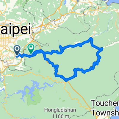
至善公園→仰德大道→陽明山國家公園遊客中心→竹子湖→陽金公路至高點(海拔約800M)→陽金公路(連續下坡約20K)→金山→萬里→大坪國小(海拔約400M陡下坡及髮夾彎)→風貴嘴至高點(海拔約600M)→(連續下坡約7K)→楓林橋→明德樂園→平菁路→平等國小(海拔約400M)→逃玩小鎮→青山小鎮→冷水坑
- -:--
- Duration
- 74.9 km
- Distance
- 1,995 m
- Ascent
- 1,604 m
- Descent
- ---
- Avg. speed
- 802 m
- Max. altitude
Route quality
Waytypes & surfaces along the route
Waytypes
Road
39.7 km
(53 %)
Quiet road
4.5 km
(6 %)
Surfaces
Paved
36 km
(48 %)
Asphalt
34.5 km
(46 %)
Paved (undefined)
1.5 km
(2 %)
Undefined
39 km
(52 %)
Route highlights
Points of interest along the route
Point of interest after 0 km
至善公園
Continue with Bikemap
Use, edit, or download this cycling route
You would like to ride 陽金P字山道 or customize it for your own trip? Here is what you can do with this Bikemap route:
Free features
- Save this route as favorite or in collections
- Copy & plan your own version of this route
- Sync your route with Garmin or Wahoo
Premium features
Free trial for 3 days, or one-time payment. More about Bikemap Premium.
- Navigate this route on iOS & Android
- Export a GPX / KML file of this route
- Create your custom printout (try it for free)
- Download this route for offline navigation
Discover more Premium features.
Get Bikemap PremiumFrom our community
Other popular routes starting in Taipei
 台北←→桃園三坑老街
- Distance
- 111 km
- Ascent
- 321 m
- Descent
- 315 m
- Location
- Taipei, Taipei, Taiwan
 小鐵人宜蘭兩日20160423
- Distance
- 89.5 km
- Ascent
- 585 m
- Descent
- 589 m
- Location
- Taipei, Taipei, Taiwan
 陽金3P
陽金3P- Distance
- 114.6 km
- Ascent
- 2,046 m
- Descent
- 1,741 m
- Location
- Taipei, Taipei, Taiwan
 大稻埕→西濱→竹圍漁港→永安漁港
- Distance
- 67.8 km
- Ascent
- 95 m
- Descent
- 89 m
- Location
- Taipei, Taipei, Taiwan
 秘境之旅-南港,汐止,平溪,石碇
- Distance
- 66.8 km
- Ascent
- 1,419 m
- Descent
- 1,418 m
- Location
- Taipei, Taipei, Taiwan
 系列七 海王星-闊瀨尋奇
- Distance
- 82.8 km
- Ascent
- 1,299 m
- Descent
- 1,281 m
- Location
- Taipei, Taipei, Taiwan
 陽金P字山道
- Distance
- 74.9 km
- Ascent
- 1,995 m
- Descent
- 1,604 m
- Location
- Taipei, Taipei, Taiwan
 阿柔洋-政大道南橋
- Distance
- 13 km
- Ascent
- 688 m
- Descent
- 698 m
- Location
- Taipei, Taipei, Taiwan
Open it in the app