
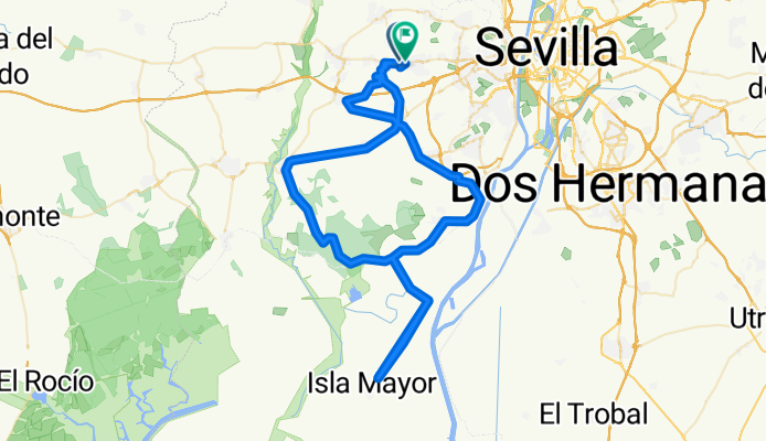
Isla Mayor por Almensilla
A cycling route starting in Espartinas, Andalusia, Spain.
Overview
About this route
Espartinas - Umbrete - Benacazón - Bollullos de la Mitación (bypass) - Almensilla - Coria del Río - Puebla del Río - Colina Junction - Poblado Alfonso XIII - ISLA MAYOR (AV) - Poblado Alfonso XIII - Colina Junction - Pinares - Aznalcázar - Bollullos de la Mitación - Benacazón - Umbrete - Espartinas.
- 5 h 59 min
- Duration
- 99.3 km
- Distance
- 332 m
- Ascent
- 341 m
- Descent
- 16.6 km/h
- Avg. speed
- 145 m
- Max. altitude

Route quality
Waytypes & surfaces along the route
Waytypes
Road
19.9 km
(20 %)
Quiet road
14.9 km
(15 %)
Surfaces
Paved
18.9 km
(19 %)
Unpaved
9.9 km
(10 %)
Asphalt
13.9 km
(14 %)
Gravel
8.9 km
(9 %)
Route highlights
Points of interest along the route
Point of interest after 30.2 km
INICIO TRAMO LIBRE
Point of interest after 43.4 km
FIN TRAMO LIBRE
Continue with Bikemap
Use, edit, or download this cycling route
You would like to ride Isla Mayor por Almensilla or customize it for your own trip? Here is what you can do with this Bikemap route:
Free features
- Save this route as favorite or in collections
- Copy & plan your own version of this route
- Split it into stages to create a multi-day tour
- Sync your route with Garmin or Wahoo
Premium features
Free trial for 3 days, or one-time payment. More about Bikemap Premium.
- Navigate this route on iOS & Android
- Export a GPX / KML file of this route
- Create your custom printout (try it for free)
- Download this route for offline navigation
Discover more Premium features.
Get Bikemap PremiumFrom our community
Other popular routes starting in Espartinas
 Gran Fondo
- Distance
- 183.2 km
- Ascent
- 1,417 m
- Descent
- 1,414 m
- Location
- Espartinas, Andalusia, Spain
 Villamanrique por Carrión
- Distance
- 82.9 km
- Ascent
- 4,445 m
- Descent
- 4,450 m
- Location
- Espartinas, Andalusia, Spain
 El Ronquillo por N-630
- Distance
- 108.4 km
- Ascent
- 936 m
- Descent
- 932 m
- Location
- Espartinas, Andalusia, Spain
 2-01-2022
- Distance
- 76.1 km
- Ascent
- 596 m
- Descent
- 596 m
- Location
- Espartinas, Andalusia, Spain
 BURGUILLOS
- Distance
- 84.9 km
- Ascent
- 440 m
- Descent
- 433 m
- Location
- Espartinas, Andalusia, Spain
 ESCACENA
- Distance
- 73.5 km
- Ascent
- 3,765 m
- Descent
- 3,785 m
- Location
- Espartinas, Andalusia, Spain
 EL BUHO II
- Distance
- 125.4 km
- Ascent
- 3,419 m
- Descent
- 3,413 m
- Location
- Espartinas, Andalusia, Spain
 El Madroño
- Distance
- 139 km
- Ascent
- 1,690 m
- Descent
- 1,691 m
- Location
- Espartinas, Andalusia, Spain
Open it in the app