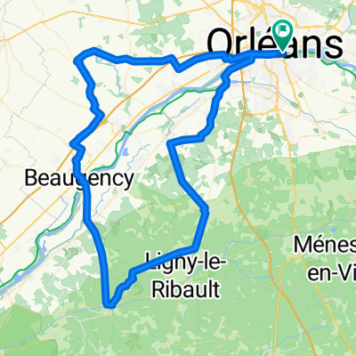
LOIRET - N-EST-84km
A cycling route starting in Saint-Jean-le-Blanc, Centre-Val de Loire, France.
Overview
About this route
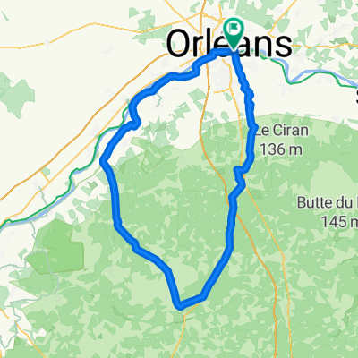
N-EAST - 84 km - Thinat bridge - Semoy - Chanteau - Rebréchien through the forest - direction Neuville - golf road - Loury - Neuville - Chilleurs - (technical stop Château Gallerand km 42) - Courcy - Ingrannes - Sully la Chapelle - Vernelles road - Tainou - Vennecy - Boigny - St Jean de Braye - Orleans
- -:--
- Duration
- 83.4 km
- Distance
- 352 m
- Ascent
- 351 m
- Descent
- ---
- Avg. speed
- 157 m
- Max. altitude
Route quality
Waytypes & surfaces along the route
Waytypes
Road
22.5 km
(27 %)
Quiet road
20.8 km
(25 %)
Surfaces
Paved
37.5 km
(45 %)
Unpaved
0.8 km
(1 %)
Asphalt
35.9 km
(43 %)
Paved (undefined)
0.8 km
(1 %)
Route highlights
Points of interest along the route
Point of interest after 41.9 km
pause technique km 42 chateau de Gallerand
Continue with Bikemap
Use, edit, or download this cycling route
You would like to ride LOIRET - N-EST-84km or customize it for your own trip? Here is what you can do with this Bikemap route:
Free features
- Save this route as favorite or in collections
- Copy & plan your own version of this route
- Split it into stages to create a multi-day tour
- Sync your route with Garmin or Wahoo
Premium features
Free trial for 3 days, or one-time payment. More about Bikemap Premium.
- Navigate this route on iOS & Android
- Export a GPX / KML file of this route
- Create your custom printout (try it for free)
- Download this route for offline navigation
Discover more Premium features.
Get Bikemap PremiumFrom our community
Other popular routes starting in Saint-Jean-le-Blanc
- LOIRET - SO - 92km orleans
- Distance
- 91.6 km
- Ascent
- 226 m
- Descent
- 229 m
- Location
- Saint-Jean-le-Blanc, Centre-Val de Loire, France
- LOIRE - SO - orleans 110km
- Distance
- 109.4 km
- Ascent
- 319 m
- Descent
- 317 m
- Location
- Saint-Jean-le-Blanc, Centre-Val de Loire, France
- LOIRET - SUD ORLEANS-marcilly-ciran-la ferté-lailly-levée
- Distance
- 90.6 km
- Ascent
- 298 m
- Descent
- 298 m
- Location
- Saint-Jean-le-Blanc, Centre-Val de Loire, France
- LOIRET S-E tigy petit parcours 83km
- Distance
- 83.5 km
- Ascent
- 301 m
- Descent
- 300 m
- Location
- Saint-Jean-le-Blanc, Centre-Val de Loire, France
- LOIRET - SE - SO - 89KM - st denis en val st cyr -ardon -jouy-cléry-meung-huisseau-
- Distance
- 89.7 km
- Ascent
- 284 m
- Descent
- 282 m
- Location
- Saint-Jean-le-Blanc, Centre-Val de Loire, France
- LOIRET Nord - 117kms - Phithiviers le Viel
- Distance
- 116.9 km
- Ascent
- 453 m
- Descent
- 453 m
- Location
- Saint-Jean-le-Blanc, Centre-Val de Loire, France
- Loire Radweg von Ost nach West
- Distance
- 444.9 km
- Ascent
- 150 m
- Descent
- 242 m
- Location
- Saint-Jean-le-Blanc, Centre-Val de Loire, France
- LOIRET S-E ORLEANS 95km
- Distance
- 94.8 km
- Ascent
- 330 m
- Descent
- 329 m
- Location
- Saint-Jean-le-Blanc, Centre-Val de Loire, France
Open it in the app