

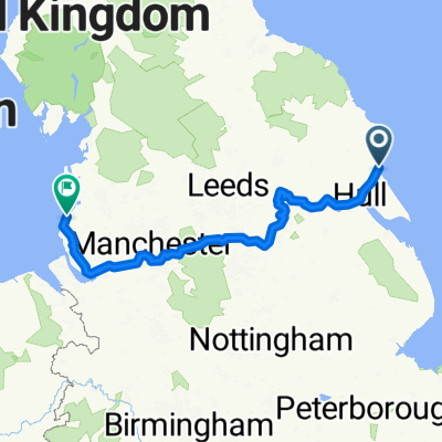
Route to Staveley Road 394
A cycling route starting in Hornsea, England, United Kingdom.
Overview
About this route
- 1 h 43 min
- Duration
- 17.9 km
- Distance
- 141 m
- Ascent
- 144 m
- Descent
- 10.4 km/h
- Avg. speed
- 44 m
- Max. altitude

Continue with Bikemap
Use, edit, or download this cycling route
You would like to ride Route to Staveley Road 394 or customize it for your own trip? Here is what you can do with this Bikemap route:
Free features
- Save this route as favorite or in collections
- Copy & plan your own version of this route
- Sync your route with Garmin or Wahoo
Premium features
Free trial for 3 days, or one-time payment. More about Bikemap Premium.
- Navigate this route on iOS & Android
- Export a GPX / KML file of this route
- Create your custom printout (try it for free)
- Download this route for offline navigation
Discover more Premium features.
Get Bikemap PremiumFrom our community
Other popular routes starting in Hornsea
 Route to Staveley Road 394
- Distance
- 17.9 km
- Ascent
- 141 m
- Descent
- 144 m
- Location
- Hornsea, England, United Kingdom
 Trans Pennine Trail
- Distance
- 312.4 km
- Ascent
- 404 m
- Descent
- 408 m
- Location
- Hornsea, England, United Kingdom
 Route from Whimbrel Avenue 38
- Distance
- 15.2 km
- Ascent
- 58 m
- Descent
- 62 m
- Location
- Hornsea, England, United Kingdom
 47 Tansley Lane, Hornsea to 49 Tansley Lane, Hornsea
- Distance
- 6.7 km
- Ascent
- 21 m
- Descent
- 23 m
- Location
- Hornsea, England, United Kingdom
 Marine Drive 1 to NCN 62
- Distance
- 333.6 km
- Ascent
- 568 m
- Descent
- 569 m
- Location
- Hornsea, England, United Kingdom
 Trans Pennine Trail
- Distance
- 312.4 km
- Ascent
- 400 m
- Descent
- 404 m
- Location
- Hornsea, England, United Kingdom
 Restful route
- Distance
- 18.2 km
- Ascent
- 70 m
- Descent
- 78 m
- Location
- Hornsea, England, United Kingdom
 National Byway (Yorkshire)
- Distance
- 359.5 km
- Ascent
- 0 m
- Descent
- 0 m
- Location
- Hornsea, England, United Kingdom
Open it in the app