
Cicletada BikeSoul 04-03-2022
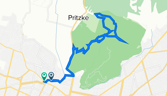
A cycling route starting in Temuco, Región de la Araucanía, Chile.
Overview
About this route
Parapentes, Connection, VaGo, to the Estero, Pata de Gallo, The Pines, Slide, Diagonal, Trauma, Little Pines, Connection, Parapentes.
- -:--
- Duration
- 12.3 km
- Distance
- 467 m
- Ascent
- 472 m
- Descent
- ---
- Avg. speed
- 328 m
- Max. altitude

Route photos

Continue with Bikemap
Use, edit, or download this cycling route
You would like to ride Cicletada BikeSoul 04-03-2022 or customize it for your own trip? Here is what you can do with this Bikemap route:
Free features
- Save this route as favorite or in collections
- Copy & plan your own version of this route
- Sync your route with Garmin or Wahoo
Premium features
Free trial for 3 days, or one-time payment. More about Bikemap Premium.
- Navigate this route on iOS & Android
- Export a GPX / KML file of this route
- Create your custom printout (try it for free)
- Download this route for offline navigation
Discover more Premium features.
Get Bikemap PremiumFrom our community
Other popular routes starting in Temuco
 sendero principal
- Distance
- 2.6 km
- Ascent
- 233 m
- Descent
- 61 m
- Location
- Temuco, Región de la Araucanía, Chile
 De Apóstol Santiago 0240, Temuco a Apóstol Santiago 0240, Temuco
- Distance
- 19.5 km
- Ascent
- 469 m
- Descent
- 470 m
- Location
- Temuco, Región de la Araucanía, Chile
 Ruta vuelta río cautín, puente entre rios
- Distance
- 41.4 km
- Ascent
- 187 m
- Descent
- 182 m
- Location
- Temuco, Región de la Araucanía, Chile
 Cicletada BikeSoul 04-03-2022
- Distance
- 12.3 km
- Ascent
- 467 m
- Descent
- 472 m
- Location
- Temuco, Región de la Araucanía, Chile
 la ruta del barro
- Distance
- 19.4 km
- Ascent
- 358 m
- Descent
- 358 m
- Location
- Temuco, Región de la Araucanía, Chile
 Vuelta Inversa al Cerro y Pasada por María Luisa
- Distance
- 24.8 km
- Ascent
- 254 m
- Descent
- 250 m
- Location
- Temuco, Región de la Araucanía, Chile
 Outdoor Sportlife Temuco - Metrenko/Makewe 36K
- Distance
- 36 km
- Ascent
- 146 m
- Descent
- 143 m
- Location
- Temuco, Región de la Araucanía, Chile
 24 del 11
- Distance
- 15.3 km
- Ascent
- 99 m
- Descent
- 97 m
- Location
- Temuco, Región de la Araucanía, Chile
Open it in the app