

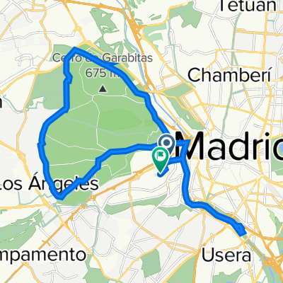
Paseo de Extremadura, 41–53, Madrid a Calle de Pericles, 28, Madrid
A cycling route starting in Madrid, Madrid, Spain.
Overview
About this route
- 1 h 25 min
- Duration
- 25.7 km
- Distance
- 647 m
- Ascent
- 640 m
- Descent
- 18.2 km/h
- Avg. speed
- 692 m
- Max. altitude

Route quality
Waytypes & surfaces along the route
Waytypes
Pedestrian area
9 km
(35 %)
Cycleway
9 km
(35 %)
Surfaces
Paved
13.9 km
(54 %)
Unpaved
9.3 km
(36 %)
Asphalt
10.8 km
(42 %)
Gravel
6.4 km
(25 %)
Continue with Bikemap
Use, edit, or download this cycling route
You would like to ride Paseo de Extremadura, 41–53, Madrid a Calle de Pericles, 28, Madrid or customize it for your own trip? Here is what you can do with this Bikemap route:
Free features
- Save this route as favorite or in collections
- Copy & plan your own version of this route
- Sync your route with Garmin or Wahoo
Premium features
Free trial for 3 days, or one-time payment. More about Bikemap Premium.
- Navigate this route on iOS & Android
- Export a GPX / KML file of this route
- Create your custom printout (try it for free)
- Download this route for offline navigation
Discover more Premium features.
Get Bikemap PremiumFrom our community
Other popular routes starting in Madrid
 River and gardens route
- Distance
- 13.3 km
- Ascent
- 99 m
- Descent
- 94 m
- Location
- Madrid, Madrid, Spain
 Vuelta a la Casa de Campo
- Distance
- 19.8 km
- Ascent
- 169 m
- Descent
- 165 m
- Location
- Madrid, Madrid, Spain
 puerta del sol-brunete
- Distance
- 11 km
- Ascent
- 130 m
- Descent
- 95 m
- Location
- Madrid, Madrid, Spain
 Experimento_Oeste
- Distance
- 144.9 km
- Ascent
- 1,409 m
- Descent
- 1,409 m
- Location
- Madrid, Madrid, Spain
 Paseo de Extremadura, 41–53, Madrid a Calle de Pericles, 28, Madrid
- Distance
- 25.7 km
- Ascent
- 647 m
- Descent
- 640 m
- Location
- Madrid, Madrid, Spain
 Casa de Campo-Guadalix de la Sierra-Torrelaguna-Torrejon del Rey-Alcala de Henares
- Distance
- 123.4 km
- Ascent
- 682 m
- Descent
- 688 m
- Location
- Madrid, Madrid, Spain
 Km.0 a Sant Cugat (1ª etapa)
- Distance
- 278.4 km
- Ascent
- 3,612 m
- Descent
- 3,555 m
- Location
- Madrid, Madrid, Spain
 Madrid-Lisboa-Compostela
- Distance
- 1,252.1 km
- Ascent
- 1,292 m
- Descent
- 1,693 m
- Location
- Madrid, Madrid, Spain
Open it in the app