

陽金3P
A cycling route starting in Taipei, Taipei, Taiwan.
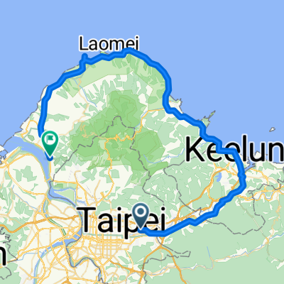
Overview
About this route
- -:--
- Duration
- 114.6 km
- Distance
- 2,046 m
- Ascent
- 1,741 m
- Descent
- ---
- Avg. speed
- 791 m
- Max. altitude

Route quality
Waytypes & surfaces along the route
Waytypes
Road
42.4 km
(37 %)
Quiet road
14.9 km
(13 %)
Surfaces
Paved
58.4 km
(51 %)
Asphalt
56.1 km
(49 %)
Paved (undefined)
2.3 km
(2 %)
Undefined
56.1 km
(49 %)
Route highlights
Points of interest along the route

Point of interest after 22.4 km
第一補給休息點. 約休停7分鐘

Point of interest after 22.4 km

Point of interest after 22.4 km

Point of interest after 47.5 km
補胎示範中

Point of interest after 47.5 km

Point of interest after 47.5 km
第二休息補給點 補給+打屁+觀賞補胎 約 40 分鐘

Point of interest after 47.8 km

Point of interest after 52.6 km

Point of interest after 55.3 km

Point of interest after 63.6 km

Point of interest after 66.8 km
第三休息補給點 喝蕃薯湯/竹筍湯/果汁/鬆餅+打屁 約 60 分鐘

Point of interest after 66.8 km

Point of interest after 87.9 km

Point of interest after 87.9 km

Point of interest after 87.9 km

Point of interest after 87.9 km

Point of interest after 100.6 km
集合出發點
Continue with Bikemap
Use, edit, or download this cycling route
You would like to ride 陽金3P or customize it for your own trip? Here is what you can do with this Bikemap route:
Free features
- Save this route as favorite or in collections
- Copy & plan your own version of this route
- Split it into stages to create a multi-day tour
- Sync your route with Garmin or Wahoo
Premium features
Free trial for 3 days, or one-time payment. More about Bikemap Premium.
- Navigate this route on iOS & Android
- Export a GPX / KML file of this route
- Create your custom printout (try it for free)
- Download this route for offline navigation
Discover more Premium features.
Get Bikemap PremiumFrom our community
Other popular routes starting in Taipei
 中社爬坡路徑
- Distance
- 4.3 km
- Ascent
- 294 m
- Descent
- 54 m
- Location
- Taipei, Taipei, Taiwan
 復興南路穿南港南深路轉景美溪回
- Distance
- 44.9 km
- Ascent
- 302 m
- Descent
- 304 m
- Location
- Taipei, Taipei, Taiwan
 2015 JAN 20-29 個人台灣環島
- Distance
- 1,029.1 km
- Ascent
- 1,680 m
- Descent
- 1,680 m
- Location
- Taipei, Taipei, Taiwan
 腳踏車環島 2011/01/20~2011/01/31
- Distance
- 1,239.7 km
- Ascent
- 1,590 m
- Descent
- 1,590 m
- Location
- Taipei, Taipei, Taiwan
 信義河濱-故宮-平等里-冷水坑-二子坪-八拉卡-紅樹林-河濱-公館(O型)
- Distance
- 84.1 km
- Ascent
- 1,319 m
- Descent
- 1,338 m
- Location
- Taipei, Taipei, Taiwan
 三橫一豎+花東海岸線
- Distance
- 1,118.3 km
- Ascent
- 8,871 m
- Descent
- 8,871 m
- Location
- Taipei, Taipei, Taiwan
 P字道
P字道- Distance
- 76.1 km
- Ascent
- 2,461 m
- Descent
- 2,021 m
- Location
- Taipei, Taipei, Taiwan
 20081011 北海岸1
- Distance
- 80.8 km
- Ascent
- 392 m
- Descent
- 383 m
- Location
- Taipei, Taipei, Taiwan
Open it in the app