

Kirche San Leonardo - Kirche Heilig Kreuz
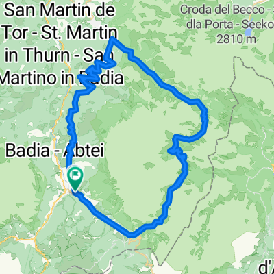
A cycling route starting in Abtei-Badia, Trentino-Alto Adige, Italy.
Overview
About this route
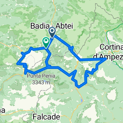
My hardest tour so far, it was uphill to the rather famous pilgrimage church of 'Heilig Kreuz', nearly 700 m of elevation gain over just about 4 km of gravel path alongside a ski lift and a ski slope..., I had to extend the way back since I would never have made it down that same path unscathed on my cross bike.
- -:--
- Duration
- 15.8 km
- Distance
- 933 m
- Ascent
- 933 m
- Descent
- ---
- Avg. speed
- ---
- Max. altitude

Continue with Bikemap
Use, edit, or download this cycling route
You would like to ride Kirche San Leonardo - Kirche Heilig Kreuz or customize it for your own trip? Here is what you can do with this Bikemap route:
Free features
- Save this route as favorite or in collections
- Copy & plan your own version of this route
- Sync your route with Garmin or Wahoo
Premium features
Free trial for 3 days, or one-time payment. More about Bikemap Premium.
- Navigate this route on iOS & Android
- Export a GPX / KML file of this route
- Create your custom printout (try it for free)
- Download this route for offline navigation
Discover more Premium features.
Get Bikemap PremiumFrom our community
Other popular routes starting in Abtei-Badia
 Maratona dles Dolomites
- Distance
- 137.5 km
- Ascent
- 3,883 m
- Descent
- 3,539 m
- Location
- Abtei-Badia, Trentino-Alto Adige, Italy
 Campolongo_Pellegrino_Valles_2015_2
- Distance
- 104.3 km
- Ascent
- 2,326 m
- Descent
- 2,684 m
- Location
- Abtei-Badia, Trentino-Alto Adige, Italy
 alta Badia Fanes 58-1800
- Distance
- 57.8 km
- Ascent
- 1,694 m
- Descent
- 1,698 m
- Location
- Abtei-Badia, Trentino-Alto Adige, Italy
 I parchi
- Distance
- 32.6 km
- Ascent
- 1,170 m
- Descent
- 1,171 m
- Location
- Abtei-Badia, Trentino-Alto Adige, Italy
 140 Maraton DOLOMITI
- Distance
- 144.1 km
- Ascent
- 5,971 m
- Descent
- 5,870 m
- Location
- Abtei-Badia, Trentino-Alto Adige, Italy
 Strada Armuntarora nach Passo Falzarego
- Distance
- 11.6 km
- Ascent
- 701 m
- Descent
- 139 m
- Location
- Abtei-Badia, Trentino-Alto Adige, Italy
 hotel-linder-neu-groeden-pralongia-hochplateau - proposed
- Distance
- 45.5 km
- Ascent
- 2,099 m
- Descent
- 2,099 m
- Location
- Abtei-Badia, Trentino-Alto Adige, Italy
 Sella Ronda clockwise completed (facut)
- Distance
- 66.4 km
- Ascent
- 3,370 m
- Descent
- 3,369 m
- Location
- Abtei-Badia, Trentino-Alto Adige, Italy
Open it in the app